"The HADCS is a secure data communication system between CFS Alert and Ottawa. The system is, in part, composed of a chain of six, line-of-sight microwave repeaters between CFS Alert to Eureka with a satellite link between Eureka and Ottawa." -Canadian ForcesIn 1981-1982 the The High Arctic Data Communication Systems (HADCS) was built and turned on to connect CFS Alert with a communications Satellite to facilitate voice and data network communication with the rest of the Department of Defence, as well as the rest of the world. UHF (~900Mhz) repeaters were set up across Ellesmere Island to bounce the signal from the top of the world, where no satellite was in view due to the curvature of the earth, to Eureka, the closest suitable spot where a satellite dish can "see" a geosynchronously orbiting satellite. Interestingly, I found reference that the signal from the Satellite link terminates at the Sir Leonard Tilley building, not CFS Leitrim as I expected.
Reportedly, when the HADCS I system was upgraded to HADCS II in ~1998, the system's speed was upgraded to 6.312 Mbps (T2), and the frequencies were changed to true "Microwave", 1900~2100Mhz.
Satellite images of Ellesmere Island are scarce, but The Atlas of Canada's Topographic maps are available for further inspection. From poking around with all available open source maps, below is a Google Map using the best guess I have for where the microwave relays are located. Of the pictures I could find, I assume the solar panel is facing South, therefore I can guess which general direction the microwave repeaters are "repeating".
I still haven't found out where Whiskey is located, but from the Jerry Proc Web Pages, they cite
"The repeaters are generally located on mountain tops that have a clear view to the neighbouring repeater. The separations between pairs of repeaters vary from 18 km (Black Top to Skull) to 121 km (Grant to Ida). The highest repeater site is Grant at 1256 m (4120 ft.) above sea level."So, if you go NE from Yankee, or SW of Victor (a distance between them of ~130Km, you should find Whiskey less than 121km away at a height of less than 1256 m. Perhaps on the Agassiz Ice Cap?
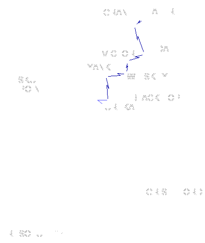 |
| "The HADCS microwave link spans the northern half of Ellesmere Island.
The repeaters are generally located on mountain tops that have a clear
view to the neighbouring repeater. The separations between pairs of repeaters
vary from 18 km (Black Top to Skull) to 121 km (Grant to Ida). The highest
repeater site is Grant at 1256 m (4120 ft.) above sea level. The
system consists of repeaters named as follows: Grant, Ida, Victor, Whiskey,
Yankee, and Black Top. Skull Point is the location of the Eureka satellite
dishes.
(Graphic source unknown at this time)" Courtosey of The Web Pages Of Jerry Proc |
From Skull Point to Alert, here is what the repeaters look like
No Picture Available
SGT Skull Point
( 80.0081066,-86.3879192 )
( 80.0081066,-86.3879192 )
 |
| HADCS Site Black Top (Facing SE) ( ~80.0031463,-85.4310326 ) |
 |
| HADCS Site Victor (Facing SE) ( ~81.3399842,-74.769984 ) |
 |
| HADCS Site Yankee (Facing WSW) ( ~80.7067817,-81.0173826 ) |
 |
| HADCS Site Ida (Facing NW) ( ~81.5777492,-69.3846524 ) View of site IDA, on Ellesmere Island, Nunavut, on 10 June, during Operation NEVUS 2013. Photo: Captain Ray Connelly, 438 Tactical Helicopter Squadron Source: Flickr - Joint Task Force North |
 |
| HADCS Site Whiskey (Facing SE) (Coordinates Unknown) A CH-146 Griffon helicopter slings a battery over the site WHISKEY on Ellesmere Island, Nunavut during Operation NEVUS 2013. Photo credit: Captain Eli Squires, Joint Task Force (North) Source: http://www.cfna.forces.ca/articles/2013/07/08-eng.asp |
 |
| HADCS Site Whiskey (Facing NW) (Coordinates Unknown) A CH-146 Griffon helicopter lands at Site WHISKEY on Ellesmere Island, Nunavut, on 9 June, during Operation NEVUS 2013. Photo: Captain Ray Connelly, 438 Tactical Helicopter Squadron Source: Flickr - Joint Task Force North |
 |
| HADCS Site (Facing NE) (Unknown Location - Maybe Grant?) FA2007-0140 16 March 2008 Ellesmere Island, Nunavut A CH-146 Griffon helicopter landed on a High Arctic Data Communication Systems site (HADCS). CF Photo by Sandy Flacht Source: Flickr RCAF-ARC |
No Picture Available
HADCS Site Grant
( 82.4912854,-65.0851054 )
( 82.4912854,-65.0851054 )
References:
- (U) Investigation of a Photovoltaic/Battery Hybrid System for Powering The High Arctic Data Communications System Final Report - National Defence
http://www.dtic.mil/dtic/tr/fulltext/u2/a218353.pdf - http://jproc.ca/rrp/alert_power_system.html
- http://jproc.ca/rrp/alert.html
- http://www.ve3kbr.com/articles/im_wired_cfsalert50_e.pdf
- http://www.rcaf-arc.forces.gc.ca/en/8-wing/alert.page
- Operation NEVUS: The Northern Information Highway
http://www.cfna.forces.ca/articles/2013/07/08-eng.asp - http://atlas.nrcan.gc.ca/site/english/toporama/


