December 30, 2013

The Marathon Gap Filler Annex

Neys Provincial Park, Ontario 
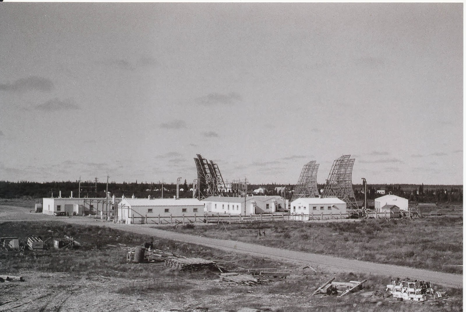
Believe to be located in Neys Provincial Park, the exact location of the Marathon Gap Filler Annex is presumed to be the location of a current commercial antenna tower, which can be seen from the Google Maps satellite imagery.  What exactly remains is unknown, I would expect foundations, and perhaps evidence of a fence.
It's worth mentioning that this site, while remote, does have a fully functioning campground nearby, and therefore may have physical security at the entrance to the access road that leads up the mountain (like a farm gate).  I was pleasantly surprised that wasn't the case at Mont Ste Marie, and similarly, I hope there are no barricades here either.  The road to the top of 5 Kilometres of dirt road, but I know it has to be passable by some kind of full size maintenance vehicle, so travel in a 3/4 ton Suburban must be possible.  4WD may be required.  Worst case, I can walk it!


View Larger Map


The Oba Gap Filler Annex


Oba, Ontario
This could be called The Grudge. During my 2012 Northern Ontario trip I didn't quite get to the Oba GFA, but now know how to get there, so the next time should be much easier than the last time. From where the Suburban will be able to get it's about a 5Km hike to the top of the hill where the two Steelox buildings and 100,000 gallon fuel tank should be.

The dotted line below shows what I will need to traverse on foot, and most of the path is actually an old logging road, now likely used by hunters and such. On the far side of the tracks the road is the original Gap Filler Annex access road. As there was a fire tower at the location, I expect the road will still be cleared of scrub, and shouldn't have any obstacles or wash outs. The distance is ~7.5 Kilometres from the green dot (safe parking spot) and the red circle (the Oba Gap Filler Annex). From the reconnaissance I did in 2012, I can tell you, this is the least problematic way to access the site, unless you know some one who can get you a lift with CN freight or VIA Rail and drop you at the Neswabin siding (and if you do - get in touch!).


Don't believe me?  Think there's a better way?  Here is the Google satellite view AND Bing view; show me a better way that doesn't involve a water crossing.  Also, the rail line is extremely active with steep gravel embankments on either side of the track - there's no way to "walk along the track" (legally or illegally)


View Larger Map


Nipigon Gap Filler Annex

Nipigon, Ontario
Located 14 Kilometres off the pavement, West of Nipigon, on the top of a hill, is likely where the Nipigon Gap Filler Annex was located.  There is at least one active antenna tower on the site today, and therefore the access road must be in good enough condition for maintenance crews to pass.  It's hard to judge the condition of the entire road without visiting the site, or knowing if there is a "farm gate" blocking vehicular access


View Larger Map


Belleterre GFA

Belleterre, Quebec
Belleterre is a community originally based on a gold rush.  While the mine closed down decades ago, it seems with the higher price of Gold renewed interest in the previously uneconomical veins has been rekindled.  I'm not sure if the mine is active today, or if they're still looking for the best vein to explore.
The geology is less interesting to me than the location of a Gap Filler Site, 50% constructed by ~1963, on a nearby mountain top.  Local reports indicate the foundations remain, potentially some original telephone poles, and some of the original perimeter fence.  The location is still used for antennas today, and the satellite photos show two buildings standing (as well as something in the woods to the East...)

Belleterre Gap Filler Annex


Timmins GFA

Timmins, ON
What remains of the Timmins Gap Filler Site is being put to good use by the Kamiskotia Snow Resort; the generator building and the tower are still standing - it's a great example of reusing and re-purposing buildings.  The mixed-use Gap Filler tower was built there in the early 1960s, and the dual purpose fire tower / radar tower is still standing. I was able to park at the bottom and climb to the top.  A Jeep using 4WD or ATV would be able to make it up the hill in the summer, but I'm not sure if the owners of the ski hill would appreciate it.


View Larger Map


Created with Admarket's flickrSLiDR.

Manitouwadge Gap Filler Annex

Manitouwadge, ON
From the satellite and available photos I'm not sure what is left of the Manitouwadge GFA.  There looks like there is a well maintained road and a modern antenna on the top of the hill, so I assume the road is used actively for maintenance of the gear which is still up there, and should be passable. Manitouage was never completed, but it's positioning was attractive to future communications needs, and now has some kind of commercial tower at the location.  This is very handy for me, as the road needs to have a degree of maintenance for crews to service the tower.


View Larger Map


November 30, 2013

Mid-Canada Line Site 410 - Cape Jones

Site 410
From this picture (Credit to Julian Pullara) you can clearly see the landing strip in the background, and the troposcatter antennas in the foreground - along with the buildings which are still standing, and the Diesel storage tanks.

Site Name: Mid-Canada Line Site 410
Location: Cape Jones, Quebec
Built: 1957 
Operational: 1957 - 1965 
Coordinates: 54.63808, -79.74785 
Lot/Concession:
Condition: Abandoned
Current Ownership:Unknown, likely Gov't of Quebec
Distance from paved road: Accessible only by air, perhaps water
Condition of access road: Unpaved


Overview/Background:

A troposcatter repeater station was set up at Cape Jones to transmit across James Bay to Mid-Canada Line Site 415 - Cape Henrietta Maria as well as communicate East to Sector Control Station 400 Great Whale River.


Larry Wilson has pictures on his web site of MCL Site 410
http://www.lswilson.ca/capjones.htm

 
Here is a video about the environmental impact the MCL sites are having on aboriginal communities.


Directions:

There's a gravel airstrip of unknown condition at (54.63960,-79.70678), but I do not know who has landed on it and what condition it is presently in.  Boat access might be easier to arrange.


Trip Report:

I have not yet been to the Mid-Canada Line 410 Cape Jones site, but it is one of the more realistic MCL sites for me to get to.  Unlike MCL Site 415 which is extremely far from road access; Cape Jones isn't too far up the coast from the Cree community of Chisasibi.  Chisasibi is road accessible and at the end of the James Bay Highway.  The general idea being; if I can get that far, what's a little jaunt up the coast in a motor-boat driven freight canoe? (see map below for illustration)


Maps:


Here Maps makes it incredibly difficult, if not impossible, to embed their maps, so here's a link to the best satellite imagery I can find.

http://her.is/L3d7F

Mid-Canada Line Site 410 Cape Jones Troposcatter Site in Red - Landing Strip in Green
atlas.gc.ca


Route from Carp, ON to Chisasibi, QC

View Larger Map

Mid-Canada Line Site 415 - Cape Henrietta Maria

Mid Canada Line Radar Site 415
Photo: Julian Pullara
Site Name: Mid-Canada Line Site 415
Location: Cape Henrietta Maria, Ontario
Built: 1957 
Operational: 1957 - 1965  
Coordinates: 54.732, -82.408 
Lot/Concession:
Condition: Remediated?
Current Ownership: Unknown
Distance from paved road: Accessible only by air, perhaps water
Condition of access road: Unpaved


Overview/Background:

A troposcatter repeater station was set up at Cape Henrietta Maria to transmit across James Bay to Mid-Canada Line Site 410 - Cape Jones as well as communicate with Sector Control Station 500 Winisk.  I'm unclear how the DDS sites between Cape Jones and Cape Henrietta Maria communicated with each other, as I believe there were two on the Bear Islands.  Also, I'm unclear how Cape Henrietta Maria communicated with Winisk.


Larry Wilson has pictures on his web site of MCL Site 415
http://www.lswilson.ca/scs400.htm
Here is a very detailed report, including maps, pictures and details of the remains of MCL Site 415
http://www.merc.ontera.net/reports/mclrs-01.pdf

Here is a video about the environmental impact the MCL sites are having on aboriginal communities.


Directions:

There's a gravel airstrip of unknown condition at (54.756213, -82.398964) that is just north-east of where the Cape Henrietta Maria site was.  Good luck!

Here is a video from someone who flew in, in spring of 2012.

Trip Report:

I have not visited the site, would love to, but realistically I don't see it happening without major financial backing.  This is just a palce-holder for the information I've gathered for a potential trip.

Maps:


Mid-Canada Line Site 050 - Fort Albany, Ontario


Site Name: Mid-Canada Line Site 050
Location: Fort Albany, Ontario 
Built: 1956
Operational: 1957 - 1965  
Coordinates:
Lot/Concession:
Condition: Remediated
Current Ownership: Unknown
Distance from paved road: Accessible only by air or winter road (January-March)
Condition of access road: Unpaved, walk-able from the airport


Overview/Background:

A troposcatter repeater station was set up at Fort Albany to connect Mid-Canada Line Site 415 Cape Henrietta Maria and Sector Control Station 500 Winisk with Mid-Canada Line Station 060 Relay.

When Fort Albany's Mid-Canada Line troposcatter repeater site was abandoned, the Diesel generators and power distribution equipment continued to be used by the local population, since it was in such close proximity.  In hindsight, if the transformers and electrical equipment which contained PCB contaminated oils, had been taken away at that time, there would likely have been less contamination of the site.  However, the site was left to fester, and contaminate the local environment.  It would seem that the site has now been sufficiently remediated and no further contamination is occurring.

Here is a very detailed report, including maps, pictures and details of the remains of MCL Site 050
http://www.merc.ontera.net/reports/mclrs-01.pdf

Here is a video about the environmental impact the MCL sites are having on aboriginal communities.


Directions:

If you were to fly into Fort Albany, the airport is less than a 2 Km walk from where the site was located (see map below). 


Trip Report:

I have not visited the site, and have no immediate plans to, this is just a palce-holder for the information I've gathered for a potential trip.

The POL site (Diesel Storage) is still standing and fenced off, but east and west of it are bare areas which look to have had buildings.  I am not sure which buildings were at which area, but presume the generators were located to the west where transformers and power lines can still be seen, and barracks to the east where the outline of foundations can be seen.

I believe the picture below (as Mike Milinkovich pointed out) is of Fort Albany, since it has a village in the background.  If so, this picture was likely taken facing Westward, and the power house, housing the diesel generators, is on the left of the picture with a small horizontal Diesel tank peeking around the back of the building from this angle.  This would put this picture as being taken from around where the Diesel tanks are now at the POL site (just left of the green arrow on the map) perhaps from on top of the tank, for the angle, since it looks like it was taken at an elevation.

"Site Up North" - Is this an picture of Fort Albany from the late 1950s?
Photo by Raymond Fortin

Maps:

Mid-Canada Line Site 050 - Fort Albany
atlas.gc.ca

View Larger Map

Mid-Canada Line Site 060 - Relay, Ontario

Site Name: Mid-Canada Line Site 060
Location: Relay, Ontario  
Built: 1956
Operational: 1957 - 1965  
Coordinates: 49.9991, -81.6191
Lot/Concession:
Condition: Remediated
Current Ownership: Unknown
Distance from paved road: ~15 Km, unpaved, in good condition (last ~5 Km by foot)
Condition of access road: Last 5 Km impassable, walk-in only.


Overview/Background:

The Mid-Canada Line Site in Relay, Ontario was just that, a relay - I don’t think there was anything there before the 1950s when the site was set up.  It was a mid-point between Mid-Canada Line Site 050 - Fort Albany and Mid-Canada Line Site 070 - Mount Kempis.  The troposcatter link couldn't make it all the way from Mount Kempis to Fort Albany, so this was simply a repeater to keep the signal going.  It was set beside the railroad, which facilitated transport of Diesel and supplies.  The facility was powered off diesel generators, perhaps because of the remoteness of the location, or the need for constant redundant power.

Here is their very detailed report, including maps, pictures and details of the remains (prior to 2009 cleanup) at Relay (MCL Site 060)
http://www.merc.ontera.net/reports/mclrs-01.pdf


Here is a video from the remediation of Mid-Canada Line Site 060


Here is another video about the environmental impact the MCL sites are having on aboriginal communities.


Directions:

Relay is ~90 Km North of Smooth Rock Falls, mostly along HWY 634, which is ~56 Km West of Cochrane along HWY 11.  Take HWY 634 North from Smooth Rock Falls until you reach (49.897534, -81.668710) which is about 77Km along the 634 from Smooth Rock Falls.  Turn right and continue 10.5 Km until you reach (49.973622, -81.609712), then park.  The rest of the way the road was demolished by the contractors who built up the original road. Berms, ditches, and boulders block the way - as can be seen from the satellite photos.  I do not understand why a policy of area-of-denial was in effect, but the road for the last ~5 Km is trashed.  Hiking in is the only way to get to the site. The good thing is that hundreds if not thousands of heavy truckloads of PCB contaminated soil were hauled out of this site just a few years ago, so the roads are in good shape overall.


Trip Report:

I have not yet visited the site, but from the satellite photos and what I've been able to research online, the site was dug up and remediated by the Ontario Ministry of Natural Resources in collaboration with The Department of National Defence, and several private companies who bid on the cleanup effort.

Maps:

MCL Site 060 Relay Location
atlas.gc.ca


View Larger Map


Here are the obstacles along the way:


November 27, 2013

Mid-Canada Line Site 070 - Mount Kempis, Ontario

Site Name: Mid-Canada Line Site 070
Location: Mount Kempis, Ontario
Built: 1956
Operational: 1957 - 1965
Coordinates: 48.3767, -80.2679
Lot/Concession: Cook. Con 1. Lot 12
Condition: Remediated
Current Ownership: Unknown
Distance from paved road: ~1.5Km
Condition of access road: Once off Highway 11 the main access road is North Butler Lake Road, an unpaved but well maintained road.  The side roads to locations of the antennas and where buildings would have been are in good shape, 4-Wheel Drive is not required (but additional clearance for rocks on the road would be beneficial)

Overview/Background:

The Mid-Canada Line was a radar fence set up West-East across all of Canada to supplement the Pinetree Line. The fence proved too remote to be economically feasible, and was shut down only years after it was set up. While it was working, tens of thousands of enlisted personnel and civilian employees constructed and maintained a line of refueling stations and radar outposts across the country. The radar signals gathered were bounced from Fort Albany to Kempis Mountain via Troposcatter Repeaters. Each of the "hops" along the troposcatter repeaters required enormous amounts of power, and because of the remote location of these bases, they were fueled by massive diesel generators. Unfortunately Diesel and lubricants were spilled at many of these locations and left to fester for decades. As a result of the environmental contamination the federal government has started to clean up these locations, dig up the contaminated soil, and the surrounding area, truck off the soil for "disposal", and return the land to as it used to be - more or less. This is unfortunate for me (perhaps the only person in the world who would complain about an environmental cleanup) because the structures, roads, foundations, etc. are being dug up - leaving less for me to see when I go these locations! I'm still visiting these "cleaned up" sites, as the buildings themselves are only one aspect of the location. The view from the tops of the mountains, the journey, the roads, the airstrips, the wildlife, and so forth, make the rest of the adventure for me.

A pair of troposcatter antennas (pointed at the horizon) were on top of Mount Kempis; as well as generators, living quarters, and reportedly even a baseball diamond.  I am not completely certain about all of what was where because it has been so well scrubbed from the site.  A trip to the National Air Photo library is needed, once again, to see aerial imagery from the time.

Directions:

If you are coming from Ottawa, take Highway 11 North from North  Bay until you reach the North Butler Lake Road turn off (48.3728, -80.2567).  North Butler Lake Road is well maintained, but I wouldn't do this trip in the winter.  Once on North Butler Lake Road there will be several turn offs to the right (North).  The first before the hydro line, the 2nd after the hydro line leads to the microwave repeater site, and the 3rd turn to the right leads to the fire tower.

Trip Report:

I have personally visited this site twice.  In late August of 2012, on the way to Northern Ontario, I arrived shortly after dawn and had a look around; after driving there in my 2WD 1999 Dodge Ram.  In 2013 I visited with Mike Milinkovich and stopped in to get a picture of him in front of the plaque commemorating the remediation of the site.  That time I did less driving around on the mountain, but had brought my 1999 (then 2WD) GMC Suburban.  As mentioned above, this is an easily accessible site, there is no 4WD-requirement.

Maps

Mount Kempis
atlas.gc.ca
Google Maps (Pre-Remdiation)

View Larger Map

Bing Maps (Post-Remediation)


Photographs

The images in the below slideshow are the pictures I took in August of 2012.


I'm very thankful to Mike Milinkovich for introducing me to Raymond Fortin who took the following pictures in the late 1950s while he was at Mount Kempis.


Electronic Test Equipment - MCL Site 070 Mount Kempis
Photo by Raymond Fortin


Equipment Room - MCL Site 070 Mount Kempis
Photo by Raymond Fortin


Equipment Room - MCL Site 070 Mount Kempis
Photo by Raymond Fortin


Test Board - MCL Site 070 Mount Kempis
Photo by Raymond Fortin


Entrance to Equipment Room - MCL Site 070 Mount Kempis
Photo by Raymond Fortin


  MCL Site 070 Mount Kempis
Photo by Raymond Fortin


Power House, Diesel Tanks, Living Quarters - MCL Site 070 Mount Kempis
Photo by Raymond Fortin


Troposcatter Antenna @ MCL Site 070 Mount Kempis
Photo by Raymond Fortin
 
Troposcatter Antennas - MCL Site 070 Mount Kempis
Photo by Raymond Fortin
Site Up North
Photo by Raymond Fortin

November 21, 2013

Composing Blogger posts using LaTeX?

I have a quandary that I'd like to figure out, but so far haven't found anyone (via Google searches) who is doing the same thing in the same way; I can't believe I'm the first to try something like this.
CTAN lion draw­ing by Duane Bibby

I realized that my visits to these Cold War-related sites that I'm undertaking is essentially amateur research. It is not Wikipedia-able, since it is new research, and based solely on my own experiences, eyes, and ears. However, I'm not doing this for Wikipedia, I'm doing it to see what's there, and see what the people who served there saw; albeit 50+ years later.  

As I learn, I update my blog with the results of my research, but often there are more details, sources of information, references to books, online resources, etc.. that I need to remember, but don't really have anywhere to store centrally. I need footnotes, endnotes, and a Bibliography for my own benefit, as well as sharing my sources with others.  Sounds a lot like the makings of a book, and while I don't specifically intend on making one, conventions regarding citations are exactly what I should be following.

So, in comes LaTeX.  I have been playing with TeXstudio (on Ubuntu) to make a shell of a book, detailing the sites I've been to.  I'm no LaTeX expert, I'm a total noob.  The book is not so much to publish, more like a personal reference.  I've now discovered I'm repeating myself and doubling my efforts between the "book" and the blog.  Other than the personal emails referenced in the "book", that I wouldn't publish to the blog, everything else is the same. Citations and references are as I'd want them online so my details can be peer reviewed.  So, shouldn't there be a way for me to write a section or chapter in a "book" using LaTeX to properly format it, then export it to HTML or display it properly via Blogspot?  Do I need to migrate to Wordpress?  Host my own blog off my own server maybe?

I'd like to move as few pieces as possible, so I'm looking for the easiest solution to keep my blog hosted via Blogger.com, but leverage the work I'm doing in LaTeX.

But WHY LaTeX? Here is why.
http://nitens.org/taraborelli/latex

If you've done something like this yourself, or know how to, I'd love to hear about it.

November 09, 2013

Tobermory GFA

The Tobermory Gap Filler Station was built around 1963 and from the satellite pictures still has both of the original buildings and fence.  I am not sure who owns the land, or if the adjacent airport owns the land.  I have not yet been there to take pictures of the site myself, and cannot find any recent pictures online.


View Larger Map

Algonquin Park GFA


Based in Algonquin Park, just off Highway 60, lies another gap filler annex.  Easy to get to, I believe it's being used for a communications tower, of some sort, from the most recent satellite imagery.  I haven't been to the location to confirm that the buildings are indeed of the right vintage, but it's highly likely this is where the GFA was located.


View Larger Map


CFS Lowther and GATR Site

Lowther Air Station was originally run by the USAF.  Once it was transferred to the RCAF, it became RCAF Station Lowther, then CFS Lowther after unification.  Other than the location, I can't say I know a lot about it. I went in August of 2012, but it had been completely levelled.  Only the roads, some remnants of sewers and foundations remained.

atlas.gc.ca
former location of CFS Lowther


View Larger Map


Lowther, Ontario - CFS Lowther GATR
The Lowther GATR site, after being decommissioned, was taken over by Hyundai, and the location is now used for cold weather testing.  From the most current satellite imagery it seems several new buildings have popped up, and I suspect there will be tight perimeter security prohibiting me from photographing the site.  I haven't made it to the CFS Lowther GATR site... yet.


View Larger Map


October 30, 2013

Russian Aerial Observation Flights Over Canada (July 17-19 2013)

Russian Tupolev Tu-154M-ON at Ottawa International Airport
Original: http://www.flickr.com/photos/53158134@N02/9783788494

Scrounging through dusty Cold War stories, I'm used to tales of Soviet-American tension, the Cuban missile crisis, heightened states of alert, drill upon drill of American and Soviet bombers; each playing a dangerous game of chicken.  I thought most of those tensions disappeared with the end of the Cold War, with the end of the Soviet state, and with the fall of the Berlin Wall.  Maybe some of them, but world military superpowers still exist, there are still treaties on nuclear disarmament, non-proliferation, chemical weapons, and all sorts of other agreements.  Adherence needs to be verified, by all signatory parties.  

I guess somewhere in the back of my mind I knew there would need to be arms inspectors ensuring everyone was playing by the rules, but I certainly didn't think Russian planes would be flying in Canadian airspace, decked out with sensors; optical, IR, radar, etc. looking down on Canadian soil, ensuring we were playing by the rules.  I don't mean that Canada is above the law, I mean I thought that was all done by Satellite by now - after all, if I can tell the type and model of a car in a parking lot using Google Maps, or Bing Maps - surely the Russian military must have better imagery, no?  That was why I was surprised to see this press release, quite after the fact;

Russian observation aircraft takes to Canadian skies under international treaty
NR-13.229 - July 13, 2013


OTTAWA – A Russian Federation aircraft will conduct aerial observation flights over Canada under the Treaty on Open Skies during the period July 17 to 19, 2013.

The unarmed Tupolev TU-154M aircraft, which arrived at 8 Wing Trenton today, will be accorded Russia’s legal right of unimpeded observation overflight of Canadian territory, in fulfilment of Canada’s obligations as a State Party to the Treaty on Open Skies. Using an array of onboard sensors, the aircraft can observe and verify objects of interest or concern, such as military sites, industrial centres, communications facilities and transportation hubs... -Canada News Center
The Treaty on Open Skies?
"...a program of unarmed aerial surveillance flights over the entire territory of its participants. The treaty is designed to enhance mutual understanding and confidence by giving all participants, regardless of size, a direct role in gathering information about military forces and activities of concern to them. Open Skies is one of the most wide-ranging international efforts to date promoting openness and transparency of military forces and activities. The concept of "mutual aerial observation" was initially proposed to Soviet Premier Nikolai Bulganin at the Geneva Conference of 1955 by President Dwight D. Eisenhower; however, the Soviets promptly rejected the concept and it lay dormant for several years. The treaty was eventually signed as an initiative of US president (and former Director of Central Intelligence) George H. W. Bush in 1989. Negotiated by the then-members of NATO and the Warsaw Pact, the agreement was signed in Helsinki, Finland, on March 24, 1992." -Wikipedia
Okay, now I know that Russians fly over Canadian airspace, spying on us, with our consent - and conversely, all of the other signatory parties do the same; Canadians over Russia, Russians over the United States, etc.. Here is a list of all the flights conducted in 2012 published May 21st 2013 (link).  

After such overflights, the imagery is then shared with all the participants in the treaty, including the host state who's land was photographed.  From another fantastic open source document I learned the imagery is supposed to be up to 0.3M in resolution, better than Google Satellite imagery (link).

So how does this interest me?  Well, the Russians are overflying and photographing "military sites, industrial centres, communications facilities and transportation hubs" many of which line up with my Cold War interests, since many bases or stations which have not been abandoned or sold off have a Cold War connection; CFB Borden, CFB Goose Bay, CFB Comox, CFB North Bay, etc... I make an effort to NOT show up at active Canadian Forces bases or stations with a camera in hand, not because I'm not interested, but because I don’t want to be accused of espionage for the Russians.  However, if the Russians are giving the Canadian Government pictures of Canadian bases - why wouldn’t that imagery be public?  I also don't know the flight paths of the Russian planes, so I don’t know if they're overflying anywhere else of interest (like Ramore, Chibougamau, old GATR sites, etc..)  Are those flight paths classified?  Again, I wonder why - as the Russians are filing their flight plan more than 72hrs in advance of their flight to ensure Canadian Forces agreement and proper notification.  If they know, and we know; what's the big secret?

I'm going to make some inquiries about the imagery, it would be very interesting to review these recent and high resolution air photos for locations which are along the lines of my interests, especially if they're already georeferenced and importable into Google Earth.

October 18, 2013

The High Arctic Data Communication Systems (HADCS) of Ellesmere Island

"The HADCS is a secure data communication system between CFS Alert and Ottawa. The system is, in part, composed of a chain of six, line-of-sight microwave repeaters between CFS Alert to Eureka with a satellite link between Eureka and Ottawa." -Canadian Forces
In 1981-1982 the The High Arctic Data Communication Systems (HADCS) was built and turned on to connect CFS Alert with a communications Satellite to facilitate voice and data network communication with the rest of the Department of Defence, as well as the rest of the world.  UHF (~900Mhz) repeaters were set up across Ellesmere Island to bounce the signal from the top of the world, where no satellite was in view due to the curvature of the earth, to Eureka, the closest suitable spot where a satellite dish can "see" a geosynchronously orbiting satellite.  Interestingly, I found reference that the signal from the Satellite link terminates at the Sir Leonard Tilley building, not CFS Leitrim as I expected.

Reportedly, when the HADCS I system was upgraded to HADCS II in ~1998, the system's speed was upgraded to 6.312 Mbps (T2), and the frequencies were changed to true "Microwave", 1900~2100Mhz.

Satellite images of Ellesmere Island are scarce, but The Atlas of Canada's Topographic maps are available for further inspection.  From poking around with all available open source maps, below is a Google Map using the best guess I have for where the microwave relays are located.  Of the pictures I could find, I assume the solar panel is facing South, therefore I can guess which general direction the microwave repeaters are "repeating". 

I still haven't found out where Whiskey is located, but from the Jerry Proc Web Pages, they cite
"The repeaters are generally located on mountain tops that have a clear view to the neighbouring repeater. The separations between pairs of repeaters vary from 18 km (Black Top to Skull) to 121 km (Grant to Ida). The highest repeater site is Grant at 1256 m (4120 ft.) above sea level."
So, if you go NE from Yankee, or SW of Victor (a distance between them of ~130Km, you should find Whiskey less than 121km away at a height of less than 1256 m.   Perhaps on the Agassiz Ice Cap?


"The HADCS microwave link spans the northern half of Ellesmere Island. The repeaters are generally located on mountain tops that have a clear view to the neighbouring repeater. The separations between pairs of repeaters vary from 18 km (Black Top to Skull) to 121 km (Grant to Ida). The highest repeater site is Grant at 1256 m (4120 ft.) above sea level.  The system consists of repeaters named as follows: Grant, Ida, Victor, Whiskey, Yankee, and Black Top. Skull Point is the location of the Eureka satellite dishes. (Graphic source unknown at this time)"
Courtosey of The Web Pages Of Jerry Proc


From Skull Point to Alert, here is what the repeaters look like


No Picture Available 
SGT Skull Point
( 80.0081066,-86.3879192 )


HADCS Site Black Top (Facing SE)
( ~80.0031463,-85.4310326 )


HADCS Site Victor (Facing SE)
( ~81.3399842,-74.769984 )


HADCS Site Yankee (Facing WSW)
( ~80.7067817,-81.0173826 )


HADCS Site Ida (Facing NW)
( ~81.5777492,-69.3846524 )

View of site IDA, on Ellesmere Island, Nunavut, on 10 June, during Operation NEVUS 2013.
Photo: Captain Ray Connelly, 438 Tactical Helicopter Squadron
Source: Flickr - Joint Task Force North


HADCS Site Whiskey (Facing SE)
(Coordinates Unknown)

A CH-146 Griffon helicopter slings a battery over the site WHISKEY on Ellesmere Island, Nunavut during Operation NEVUS 2013.
Photo credit: Captain Eli Squires, Joint Task Force (North)
Source: http://www.cfna.forces.ca/articles/2013/07/08-eng.asp


HADCS Site Whiskey (Facing NW)
(Coordinates Unknown)

A CH-146 Griffon helicopter lands at Site WHISKEY on Ellesmere Island, Nunavut, on 9 June, during Operation NEVUS 2013.
Photo: Captain Ray Connelly, 438 Tactical Helicopter Squadron
Source: Flickr - Joint Task Force North


HADCS Site (Facing NE)
(Unknown Location - Maybe Grant?)

FA2007-0140 16 March 2008 Ellesmere Island, Nunavut
A CH-146 Griffon helicopter landed on a High Arctic Data Communication Systems site (HADCS).
CF Photo by Sandy Flacht
Source: Flickr RCAF-ARC
 
No Picture Available
HADCS Site Grant
( 82.4912854,-65.0851054 )


References:

October 15, 2013

CFS Alert

You can file this one under "places that are almost impossible for me to go visit", but I found a few pictures and web sites that do give a good idea of what it would be like, so my curiosity is ever-so-slightly satisfied.

CFS Alert is at the top of the world, and is the Northernmost inhabited place on earth.  It reportedly performs SIGINT, some research, and acts as a weather station. 

Map courtesy of Nasittuq


Unfortunately there is pretty crummy Google satellite imagery of the area, potentially due to the orbit such a satellite would need, which is also the reason normal satellite communication is not possible from CFS Alert.  Communications need to be bounces along microwave relays to Eureka before a communications satellite into view.

UPDATE:
It seems someone HAS made very limited imagery of CFS Alert available


View Larger Map

CFS Alert

Because of the lack of satellite imagery I wasn't aware of the layout, size, shape, or anything really, about Alert; and wouldn't want to ask many questions of anyone who's been there, since most of the operations of CFS Alert, while many are performed by non-military members, are hush-hush.  Therefore, I was thrilled to find pictures from the air already on the public internet!

Photo courtesy of Nasittuq (click for larger image)


Photo courtesy of Nasittuq

Map courtesy of Nasittuq


This is the best map of the base I could find; but it doesn’t include the fresh water source or Plessey Pusher CDAA array.
Map courtesy of Nasittuq (click for larger image)


Southwest view along the runway in the direction of the fuel depot seen in the distance
Photo courtesy of Nasittuq
Since I was having a hard time finding the general layout of the antenna arrays, I resorted to making a composite image from several screenshots of atlas.gc.ca 1:15000 imagery.

composite image created with imagery from atlas.gc.ca

I was quite surprised how much about CFS Alert could be found with Google; there isn’t anything "new" above, and my favourite CFS Alert video is below (also, not new).