Showing posts with label History. Show all posts

June 21, 2015

SAC Reflex Action (1957-1965) Weapons Storage Areas

On October 1st 1957 the Strategic Air Command commenced an overseas alert operation, called Reflex Action, with twenty B-47 nuclear-capable bombers deployed to Sidi Slimane Air Base in Morocco.   This number would greatly expand over the course of the operation and include many more bases. Reflex operations would rotate bomber and refueling aircraft and crews to overseas bases where they would be disbursed away from CONUS, and be within striking distance of their targets.  The Reflex mission ended on March 31st 1965. (ref. Alert Operations and the Strategic Air Command, 1957-1991 - Diane Publishing Co.)

It shouldn't be surprising that the Army Corps of Engineers had designed and built Weapons Storage Areas along with the massive runways and hangers at all of the SAC air bases in the 1950s.  By all indications these WSAs were designed to handle and store open-pit detonators and nuclear bombs, to equip B-47s with a strike payload while on 90 day Reflex operations, on rotation from their home base.

Spain

Here we have the SAC Weapons Storage Area at the former Torrejon Air Base in Spain (40.4846, -3.4175)


Here we have the SAC Weapons Storage Area at the former Zaragoza Air Base in Spain (41.6482, -1.0316)


Here we have the former SAC Moron Air Base in Spain, also where B-47 Medium Bombers were deployed on Reflex missions.  Does the Weapons Storage area look at all familiar in design and layout yet?  (37.1742, -5.5947)


Morocco 

The former Ben Guerir Air Base Weapons Storage Area seems to have been expanded upon since the SAC moved out my the Moroccan Air Force, but the bones of the original (32.0988, -7.8969)


Sidi Slimane Air Base Weapons Storage Area (34.2151, -6.0419)


Nouasseur Air Base Weapons Storage Area (33.3659, -7.5530)

Canada

Goose Air Base (now CFB Goose Bay) - What do the above six US Army Corps of Engineers-designed and built USAF SAC bomber facilities have with Goose Air Base?  Goose had both Canadian forces and Canadian built buildings (at the NE side) and American facilities built on the South side.  Look at the area around where the push-pin is, and tell me what you see.  Isn't it remarkably similar in design to the nuclear Weapons Storage Areas at the above six bases?  The ring road? The earth covered magazines?  The little rectangular buildings?  Goose Air Base, now CFB Goose Bay, had the facilities to store nuclear bombs, and a squadron of B-47 Medium Bombers on loan from their bombing wing in the US, on rotation, every 90 days.  Why would you position B-47 nuclear-capable bombers, in the exact same type of facility that was built overseas (six times+) and not store nuclear bombs with them?  Clearly Goose Air Base was a forward operating location for retaliatory or first-strike against the USSR which had nuclear bombs on site. (53.2958, -60.3770)


CFB Cold Lake poses an interesting problem because it is still operation, has conventional munitions on site, and has been developed and built up by the RCAF.  It was certainly a refuelling base for KC-97 mid-air refuelling planes for Reflex, and there was (is) a Molehole at the South end of the air base where SAC KC-97 crews would be stationed on alert ready to fly.  But, did the base house any nuclear bombs during that time?  There exists an undeground facility at CFB Cold Lake to store equipment and potentially planes, but I have no evidence to suggest any of the weapons storage sites that are visible today, or underground, would have been built or used for nuclear bombs.  None of the usual buildings or layout indicating a presence of nuclear munitions are present at CFB Cold Lake (54.4021, -110.2794)

Denmark

Here we have the former SAC Sondrestrom Air Base in Greenland that was supposed to be a KC-97 refuelling base, and not a repository for nuclear weapons.  As far as I can see that's correct; there are no signs of nuclear weapons storage buildings or infrastructure to support those nuclear weapons.  Given the harsh environment, I suspect no nuclear weapons were stored at Sondrestrom Air Base. (67.0108, -50.7089)


Bermuda

Kindley Air Force Base in Bermuda was an SAC refuelling facility; other than four earth covered magazines that are overgrown with vegetation, I don't see anything that could resemble a (nuclear) Weapons Storage Area.  It looks like it was only a refuelling facility too. (32.3644, -64.6808)


England

RAF Fairford, England was host to SAC bombers as part of Reflex, and the Weapons Storage Area is slightly different, but the plant building and igloos are clearly visible (51.6792, -1.7649)


RAF Greenham Common, England, being of British design, not American, does not have the same WSA configuration as the American-built SAC sites, but clearly has hardened double fenced storage that would have been available for nuclear weapons storage.  B-47s were rotated in to the base, so it all ties together. Similar to the Canadian CFB Cold Lake, it was developed after Reflex, so it's hard to see what it would have looked like from present satellite photos (51.3774, -1.3024)


RAF Brize Norton, England was host to American SAC activity for Reflex Action, but I'm not 100% sure this munitions facility was used for nuclear bombs because of the differences in building design. (51.7408, -1.5657)


RAF Upper Heyford, England was also host to USAF SAC bombers, and has at least two Weapons STorage Areas (the other is NW of the point below, on the other side of the old runway. (51.9353, -1.2332)


So what, you ask?  Those are just the locations I pulled up out of one report (below), many more USAF air bases worldwide had Weapons Storage Facilities.  I was focusing on those which are documented as participating with the Reflex Action, since it fell smack in the middle of my are of interest with Goose Bay Air Base (1950-1971).  I'm not a PhD of architectural history, but with some common sense, I think you can see from the visuals above, you have a good sample of what air bases constructed by the Royal Canadian Air Force (CFB Cold Lake), the Royal Air Force (Brit), and the US Army Corps of Engineers look like.  My point is, they are all very different in design, and you can see from their design, what their mission was.  Large aprons or hard stands with nearby fuel farms (such as Sondrestrom AB in Greenland or Goose AB) show where refuelling planes would wait on alert.  Earth covered magazines in different configurations were arranged for safety from explosions that might happen at fuel dumps and were always located away from airplanes or other buildings in case of an explosion.  American-designed SAC Weapons Storage Areas for nuclear bombs were constructed as you see them above.  B-47 bombers were on alert at those same bases for the express purpose of dropping nuclear bombs on targets in the Soviet Union; either with a pre-emptive strike, or retaliatory strike.  The history of US Nuclear Weapons in Canada is incomplete, but I hope additional information will become declassified and reveal what the true history is of Canada's involvement with the Cold War.


Reflex seemed appropriate, no?

May 10, 2015

Reviewing the Casey Emergency Airstrip 1964 air photo

I already went over the Casey Emergency Airstrip domestic site in a previous blog post, but wanted to do a similar blog post regarding the other air photo I purchased from the National Air Photo Library.

I've been to Casey on two occasions, so this post is built on what I saw on the ground, as well as what I've put together from air photos, satellite photos, the site plan for RCAF Station Casey that Dave St-Laurent acquired from the National Archives, and some common sense derived from how other bases and stations of the time have been laid out.

From the best of my understanding, the airstrip was requested by National Defence to be built by Transport Canada, in support of the Pinetree Line project, like many other emergency airfields across Canada.  I have a document that proves that much.  Then, it seems from air photos at the National Air Photo Library, that the initial construction of the airstrip didn't have the alert apron, but by 1964 it did.  Does this indicate a 2nd phase or upgrade? Or was the first air photo I saw just mid-construction?  I'm unsure, but I believe the airstrip was upgraded in the late 1950s to accommodate emergencies with larger planes, like the B-52, rather than just air-defence interceptors like the CF-100, as I believe they had originally intended.

Dave St-Laurent retrieved from the National Archives a site plan showing a further planned expansion, but I'm unsure of the date it was drafted up.  One of the other documents I found shows that further expansion of the Casey air strip (to be called RCAF Station Casey) couldn't proceed because they couldn't find sufficient solid ground to put the buildings.  If you've been there, or look at a topographic map, you'll see the area is very swampy.  Luckily the site plan for the expansion shows the names and types of buildings that were already there, as well as showing what they planned to add.  This really helps decipher the air photo from 1964.

The full resolution TIFF image can be downloaded here (over 100Mb) so you can draw your own conclusions.

"U/S Explosives Storage"  per Site Plan
I originally thought the label of "U/S Explosives Storage" on the site plan meant United States Explosives (aka Ammo) Storage... but I now think this was for "UnStable" explosives, maybe dynamite or other such explosives that would have been used to construct the airstrip.  The location is over 500 meters from the runway, which I presume isn't a coincidence.  The same temporary structure on a cement pad with high berms around it could have been used for ammunition if a plane made an emergency landing and needed to offload munitions.

Control Tower and Bridge
It isn't clear to me what the other buildings are in this photo, but the control tower is clearly visible.

"Gravel Pit" per Site Plan
In the proposed site plan the above was shown as a "Gravel Pit", right near where the future PMQs would be, as well as a drill hall and churches.

"Old Borrow Pit" per Site Plan
I was not familiar with the term "Borrow Pit" but after looking it up, it makes sense.  I walked along the trail (shown) that goes from the runway to the NW of the picture in 2012; while quite overgrown it is passable.  Walking back, through the bush rather than the same trail, I didn't notice anything unusual, the area was relatively flat, had lots of trees, shrubs and moss, and no hint of what it had previously been used for.

"New Borrow Pit" per Site Plan
This "New borrow pit" I didn't actually get to when visiting the Casey air strip, the woods are pretty dense around there.  I guess this would have just been where clean fill would have been taken from to fill in where other uneven areas were, probably to do with the construction of the alert apron, I would guess, based on proximity.

Bridge , which isn't there anymore
Centered in the middle is where a bridge used to be, but has been washed away over the years.  The lake comes to a pinch at that spot and the crossing doesn't look to me to be possible in an ATV.  Either side is too steep, and the water looks deep.  The picture makes it look like the bridge may have been a dam; I'm not sure, since it has all been washed away.

Water well and supporting buildings
The site plan explained what this cluster of buildings above are; it's where the fresh water well that the domestic site drew water is located.  I'm unclear how many buildings were there, and how it was powered, but I see at least 3-4 buildings - perhaps they had their own generator to power the pumps?  Due to the aforementioned bridge being gone I didn't make it there.

Remote RX Site for VHF and UHF
The site plan clarified that this site is the remote VHF/UHF receiver site for the air strip.

Remote TX Site for VHF and UHF
The site plan clarified that this site is the remote VHF/UHF transmitter site for the air strip.

Alert Apron with space cleared for Alert Hangers
This space looks like it was made for upcoming development, it was where on the site plan alert hangers were supposed to be built, and makes sense since the alert apron was constructed there.  Perhaps the plan had been underway to upgrade the Casey site when the plug was pulled because of a lack of solid ground.  I dont have a date for when the Casey Air Strip was officially decommissioned, or the buildings which were there were razed, but it would have clearly been after this picture was taken in 1964.

On the RCAF Station Casey site plan (never completed) the buildings were described in the following manner.  Their labels on the map sometimes were slightly different.

No.Builidng TypeBuilding Reference
1HeadquartersS14-1016
28 Bed HospitalS15-1013
3Control TowerS42-1002
4Central Heating PlantS23-1019
5Ration DepotS17-1002
6Supply DepotS17-1003
712 Bay M.T.GarageS32-1011
8Bulk Fuel StorageC57-21-1000
9Electric Power PlantC57-22-1001
10Combined Mess (300)S31-1030
11Officer's QuartersS30-1030
12O.R.QuartersS30-1030
13O.R.QuartersS30-1030
14O.R.QuartersS30-1030
15O.R.Quarters (Future)
16O.R.QuartersS30-1030
17(not allocated)
18Sewage Disposal PlantC57-24-1001
19Main Supply Pump HouseC57-25-1000
20Explosives StoreS20-1015
21Water ReservoirC57-25-1001
22Well Pumphouse
23
24
25VHF/UHF/ADFS13-1000
26
27VHF/TX RemoteS13-1037
28VHF/RX RemoteS13-1037


May 09, 2015

Reviewing the Casey Emergency Airstrip domestic site 1964 air photo


Originally I posted this blog entry armed only with an air photo, what I saw with my own eyes while I was there, and some common sense based on what I've seen at other Canadian Forces bases and stations.  Just recently I met the acquaintance of Dave St-Laurent, who had made the trek to the National Archives and checked out the Casey file.  Based on the Site Plan for the proposed expansion for the Casey Emergency Airstrip, which would have made it a full fledged "Station", I can now definitively state what the uses were of the buildings in the 1964 air photo from the National Air Photo Library below.

The full resolution TIFF image can be downloaded here (over 100Mb) so you can draw your own conclusions.

Casey Domestic Site - Garage, Boiler, Generator, other

In the above image you can see (bottom right) the 12 bay garage which is visible from the East-West road (the road still exists today).  The SW/NE road at the left of the picture is overgrown and is not realistically passable. You'll notice the top left square building has a smoke stack, and a big pipe, suspended in the air and held up with telephone-poles.  That is the steam/heating plant fueled with diesel from the tanks off the right side of the picture.  That pipe network is the same as you'd see at any Pinetree Line site with a central heating plant.  You'll notice the top right building has at least 3 smoke stacks along the peak of the roof, and no heat/hot-water going to it - it is the diesel powered generator building, and makes its own heat!  The bottom leftmost building was Ration stores, and the middle building between it and the garage was just general storage.

Casey Emergency Airstrip - Mess Hall and other unknown buildings
The cross-shaped building is the mess hall, built to hold 300 people.  The leftmost long building was the headquarters of the base.  The top left building was an 8 bed hospital.  There are transformers on telephone polls at the bottom right of the picture, and in all of the pictures you can see telephone poles which are actually carrying power.

Casey Emergency Airstrip - Barracks
These are typical 1950s era barracks.  Each is connected to the heat pipes, as they wouldn't have their own furnaces. The top right barracks would have been for officers.  The middle section of all of them would have housed common facilities (showers, bathrooms), and each barracks is speculated to have a capacity of ~160 men.


Casey Emergency Airstrip - Diesel storage, and unknown bldg
The berms from these Diesel storage tanks are still there, but the tanks are long gone. I believe I walked over or right past where that little white building was, but I didn't see it at all.  On the site plan it is labelled "pumphouse".  I assume that's to pump the Diesel?  It doesn't seem to have any heat going to it, which is interesting; as a machinery-filled building I guess that makes sense.

Main supply pumphouse

This is labelled the "main supply pumphouse" on the site plan; the main water supply to be precise.  It is heated, clearly so the water wouldn't freeze.  It is built on a reservoir and pumps uphill to another fresh water holding tank.  The water is drawn from a well across the river on the south shore.  I didn't know what that well building was (not pictured), but so far haven't been able to get to it due to the bridge leading to it being out.


CE Building
This is labelled as the CE Building.  Unfortunately I don't know what that is, but maybe it's the Communications and Electronics building?  You'll notice it doesn't have steam pipes leading to it, so it must be making it's own heat.


Intersection to Radio Bldg
Above is the mystery intersection.  I've stood in the middle of this road, and tried to find the North (up) facing road.  I cannot.  Others with GPSes in hand have tried to find that road.  They failed too. How the N/S road up the hill to the radio site has vanished so thoroughly I have no idea.  Along the West side of that road there were telephone polls, which might help in the road's identification.  I can see on the Google and Bing satellite imagery that the road does have different vegetation on it, eventually, but it seems difficult to find the entrance to!

Casey Emergency Airstrip - VHF/UHF/ADF Bldg
This is the "gold" at the top of the hill.  Nobody has seen this building in decades.  Locals can't even find it.  It is the VHF/UHF/ADF building. This is still a major priority of mine for the next trip. 
As best as I can figure the building is at (47.94184, -74.10999).  there were also separate RX and TX buildings for UHF and VHF Northeast of the domestic site.


View Larger Map  |  Get Directions  |  View Bird's Eye

The above is what the site looks like now; overgrown.  Thankfully, the soil isn't very fertile, is mainly sand, and not a lot of serious vegetation has grown up in the area.  It could probably be cleared up and the foundations exposed with a few days of clearing operations and a team of people who are willing to get dirty.


August 03, 2014

Beyond the Diefenbunker: Canada's Forgotten "Little Bunkers" -Bill Manning, 2003

Reposting a great research report for anyone who hadn't seen it... It's not even too dated, even tho it's over 10 years old

Research report from Vol.57, Spring 2003 of Material Culture Review written by Bill Manning

HTML:
http://journals.hil.unb.ca/index.php/MCR/article/view/17956/22019

PDF:
http://journals.hil.unb.ca/index.php/MCR/article/download/17956/19231


Beyond the Diefenbunker:

Canada's Forgotten "Little Bunkers"

Bill Manning
National Museum of Science and Technology
1 Since the dismantling of the Berlin Wall in 1989, there has been a growing interest in the history of the Cold War. The work of authors Sean Maloney and Paul Ozorak, among others, has drawn attention to the Canadian government's role in national and civil defence measures during this period.1 The "Diefenbunker" at Carp, west of Ottawa, now being restored and operated as a museum, serves as a fascinating reminder of the Canadian Government's efforts to defend against nuclear attack. This complex, massive by Canadian standards, was never large enough to accommodate all the personnel and operations that would have been necessary during a national emergancy. Maloney and Ozarak allude to a network of other, smaller, facilities distributed throughout the Ottawa area. The "Diefenbunker Tours 1997" pamphlet refers to "some smaller bunkers" and to "a variety of relocation sites dotted throughout the country." The purpose of this article is to explore the role of these smaller installations within the civil defence network in the Ottawa area and illuminate an important but neglected aspect of Canada's Cold War preparations.

Historical Context

2 The Cold War developed from mutual distrust and hostility between the Soviet Union and its former Western Allies as they faced each other across a divided Europe following the Second World War. When the Soviets seized power in Czechoslovakia in 1948 and blockaded Berlin in 1948-49, the Allies responded in April 1949 by forming the North Atlantic Treaty Organization (NATO) to present a united front against communist aggression. After the explosion of the first Soviet atomic bomb in August 1949 the possibility of a devastating nuclear attack became an omnipresent concern of both sides in the Cold War.
3 In Canada, preparations against Soviet attack began as early as October 1948 with the appointment by the federal government of recently retired Major-General F. F. Worthington to the position of Civil Defence Coordinator. The office initially operated within the Department of National Defence, but in February 1951 was transferred to the Department of Health and Welfare.2 Concern over possible Soviet attack increased after the successful explosion of their first atomic bomb as tension increased during the Korean War of 1950-53. The Soviets successfully detonated a hydrogen bomb in 1954, one year after the Americans. Not only was this device vastly more powerful than the previous atomic weapons, but the adoption of inter-continental ballistic missiles (ICBMs) to replace manned bombers as the main delivery system meant that an attack could be completed with considerably less warning than was previously the case.
4 In 1956 the Liberal government of Louis St Laurent appointed an intergovernmental departmental working group to investigate Canada's civil and military preparedness. Its report, presented in January 1957, recommended the construction of an emergency headquarters for the federal government near Ottawa, and smaller regional headquarters in each province. It also recommended that the civil defence organization within the Department of Health and Welfare be reorganized into a larger agency with responsibility for co-ordinating overall "Continuity of Government" planning, and report directly to the prime minister.3
5 Within one month of winning the election of June 1957, the new Conservative government, under the leadership of John Diefenbaker, accepted the recommendations of the 1956 working group and established the new co-ordinating agency called the Emergency Measures Organization (EMO). Its Director, R B. Curry, reported to the Clerk of the Privy Council. In 1959 the government expanded the EMO's mandate to include the protection of the civilian population as well as continuity of government.4
6 The new Conservative government also approved the construction of the Diefenbunker, a huge, self-sufficient, shock-resistant, reinforced, radiation-proof underground complex with an elaborate protected communications network, built between 1959 and 1962.5 Its official name, Project EASE (Experimental Army Signals Establishment), was intended to disguise its actual role as Canadian Emergency Government Headquarters (CEGHQ). Here the prime minister, Governor-General, senior government, civil defence, judicial, police and military officials would be housed in relative safety during a nuclear attack.6
7 EASE was the nerve centre of the Emergency Radio Relay (ERR) system that linked the Diefenbunker to its regional counterparts in Debert, Nova Scotia; Valcartier, Quebec; Camp Borden, Ontario; Penhold, Alberta; and Nanaimo, British Columbia (plans for comparable facilities in Prince Edward Island, Saskatchewan, and Manitoba were never implemented). These had been built under Project BRIDGE and were known officially as Regional Emergency Government Headquarters (REGHQs). It also provided communication with NATO and North American Air Command (NORAD) headquarters as well as with air surveillance (radar) tracking stations and air defence units.
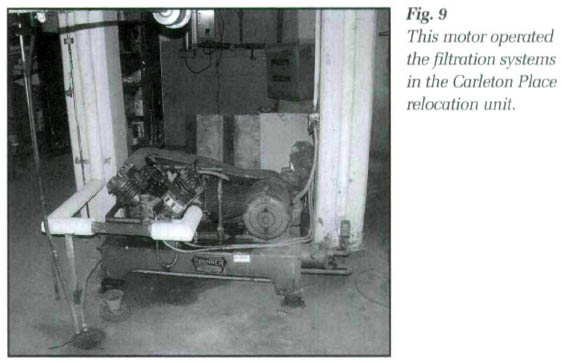
8 Each REGHQ was the focal point of its own regional communications and public emergency broadcasting network. The Canadian Army's 1st Army Signals Squadron, Royal Canadian Corps of Signals (RCCS), operated all communications systems, using the new STRAD (Signals Transmission Receiving and Distribution) computer system in the Diefenbunker. Two unattended antenna yards at Dunrobin and Almonte picked up incoming signals and relayed them through buried land lines to the main receiver inside the Diefenbunker. A third underground cable connected the Diefenbunker to a radio transmitter station at the "Richardson Detachment," located between Perth and Smiths Falls. This facility consisted of a two-story bunker and a transmitter antenna yard, manned by about twenty army communications personnel. A fourth underground cable connected Richardson to the Federal Department Relocation Site (discussed below) in the basement of the Federal Building at Smiths Falls.7
9 Nuclear tension between the two super powers reached a peak in 1962 during the Cuban Missile Crisis, when the United States and the Soviet Union came to the brink of war over the presence of Soviet nuclear warheads in Cuba. Once the Soviets agreed to withdraw their weapons, tensions began to ease as the two superpowers contemplated the consequences of their brush with mutual annihilation. In 1963 they signed the Nuclear Test Ban Treaty and ongoing negotiations ushered in a decade of détente. Canadian civil and national defence budgets, which had increased annually throughout the 1950s to peak in fiscal year 1961/62, declined thereafter as steadily as they had risen.8

Continuity of Government

10 "Continuity of Government" (COG) was defined as those measures taken to keep the essential functions of government operating during a nuclear attack, and to restore order after the emergency had subsided. Project RUSTIC provided plans for designated government officials to escape to safe havens, such as the Diefenbunker, once a nuclear attack against Ottawa was confirmed. Here, they would be accommodated during the initial "shock" phase of up to fourteen days, and then be in a position to manage the re-establishment of civil authority during the ensuing thirty-day "recovery" phase. EMO co-ordinated the overall civilian COG component, identified areas of responsibility for various departments and encouraged them to develop emergency plans, identify and store essential records and provide instructions and postings to key officials according to departmental "manning" plans.9
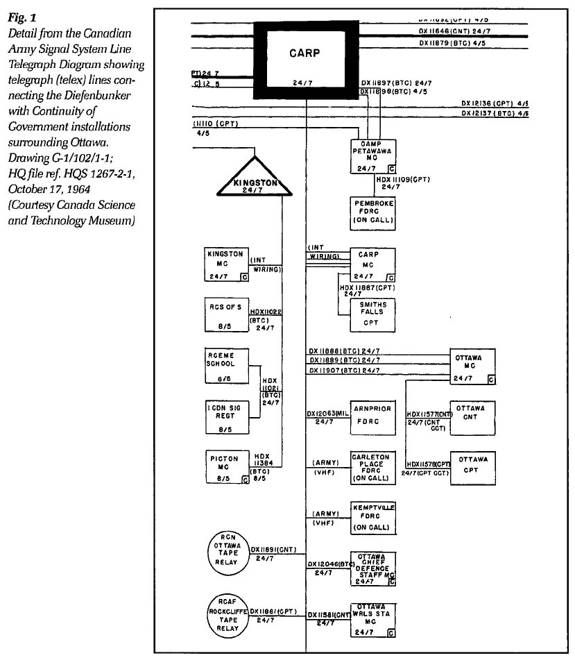
Fig. 1 Detail from the Canadian Army Signal System Line Telegraph Diagram showing telegraph (telex) lines connecting the Diefenbunker with Continuity of Government installations surrounding Ottawa. Drawing G-l/102/1-1; HQ file ref. HQS 1267-2-1, October 17, 1964 (Courtesy Canada Science and Technology Museum)
Thumbnail of Figure 1Display large image of Figure 1
11 Following the Berlin Crisis of 1948-49, the Canadian army adopted informal plans to use a number of sites in the Ottawa area as emergency headquarters in case the capital was attacked. Constructed in 1954 as a site for training civil defence workers, the Canadian Civil Defence College in Arnprior, north of Ottawa, the site of an old airfield, became the temporary emergency government headquarters. In 1957, when the decision was made to build the Diefenbunker, the Canadian Army base at Petawawa was designated interim CEGHQ until die Diefenbunker opened in 1962. This facility combined the functions of both DND military headquarters and civilian COG emergency headquarters.
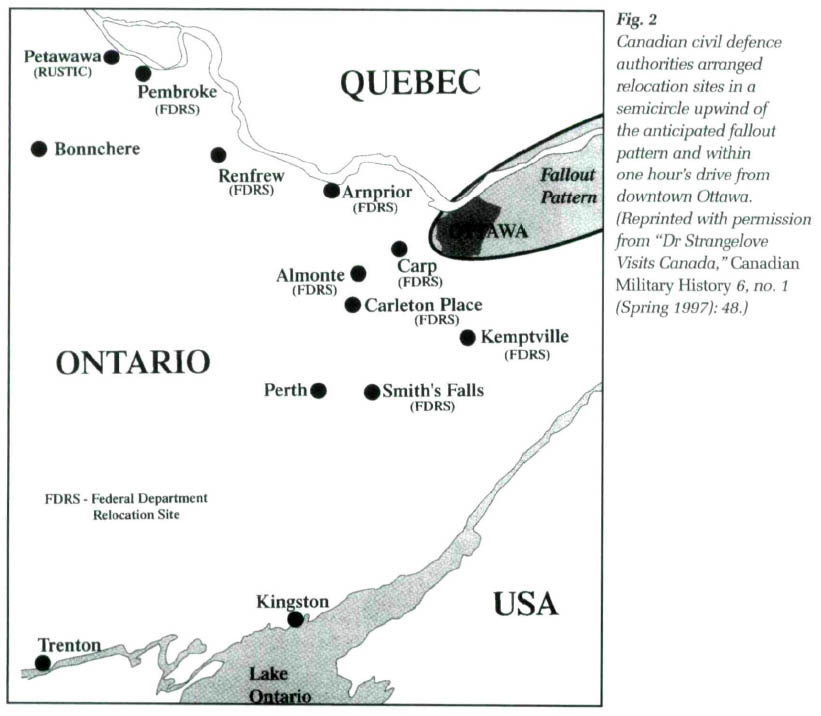
Fig. 2 Canadian civil defence authorities arranged relocation sites in a semicircle upwind of the anticipated fallout pattern and within one hoar's drive from downtown Ottawa. (Reprinted with permission from "Dr Strangelove Visits Canada," Canadian Military History 6, no. 1 (Spring 1997): 48.)
Thumbnail of Figure 2Display large image of Figure 2
12 Even as construction of the Diefenbunker began, COG planners clearly realized that the new complex would be too small to accommodate the required number of essential emergency personnel, since the search for alternate accommodations began almost immediately. A separate but related requirement was space to stockpile supplies for the relief of civilian evacuees from Ottawa in the after math of a nuclear attack. To minimize costs they considered basements in existing buildings such as schools, churches and community centres. Closer examination showed most of these buildings to be too crowded or already in use, so EMO decided to construct two entirely new buildings for this purpose, called Federal Readiness Units, in Kemptville and in Carleton Place.
13 Being above ground, these buildings were only suitable for use during the recovery phase of an attack, leaving open the question of how to accommodate additional federal emergency personnel during the shock phase. To secure the necessary "Relocation Sites," EMO devised a four-part strategy. First, it identified temporary unprotected basement accommodations in existing federal buildings in Renfrew and Pembroke. Second, it arranged for future federal buildings in suitable locations to be built with special protected basements. For example, the basement of the new Federal Building in Smiths Falls, then under construction, would become a relocation site. Third, it developed specifications for a protected basement to be included in a new building planned for the Canadian Civil Defence College in Arnprior. Fourth, two more relocation sites, each capable of accommodating forty people, were excavated beneath the Readiness Units already under construction at Kemptville and Carleton Place in 1961, at a cost of $25 671.10
14 Relocation sites served as rallying points for departmental officials with assignments under RUSTIC'S manning plans and formed centres from which these officials could carry out essential government operations and provide support to the group at the Diefenbunker. RUSTIC planners chose locations west of Ottawa, upwind of the target, to avoid radiation from the fell-out pattern, expected to be carried east of the city by the region's prevailing westerly winds. Logic dictated that they should be far enough away from the target to be immune from the immediate effects of the detonation. They should also be close enough that assigned personnel could reach them by motor vehicle in about an hour and have basic operations and communications set up within three hours.11 (Fig. 2).
15 Designated personnel were expected to report to their emergency assignments using their own automobiles, if possible, especially if an alert was broadcast outside normal working hours. Advance and intermediate parties could board special buses marked "RUSTIC" at the Supreme Court Building on Wellington Street in Ottawa and be driven to their designated emergency assignments. Alternatively, they could flag down a bus at any point along the route, using a flashlight at night. In the event of a "crash action" alert, the highest level of emergency warning, special trains would depart Union Station, the major railway transportation hub in downtown Ottawa (across from the Chateau Laurier Hotel), to take personnel to their designated relocation sites along Canadian Pacific Railway lines.12
16 The Kemptville and Carleton Place Relocation Sites were originally intended to accommodate forty people for up to fourteen or fifteen days. To maximize the use of this space, EMO adopted the "hotbed" system, rotating twelve-hour shifts so that two people shared one bed, that allowed eighty people to be sequestered under austere conditions, since only forty would be on duty or sleeping at any time.13
17 In 1961, EMO recommended to an Interdepartmental Committee on Civil Emergency Planning that the underground facilities in Kemptville and Carleton Place both be enlarged to accommodate an additional 100 people, for a total of 180 people each.14 At the same time, it arranged for the Department of Public Works to proceed with the construction of a bunker under the Canadian Civil Defence College in Arnprior, which was to accommodate 100 emergency personnel. By the time of the Cuban Missile Crisis in October 1962, however, the government had only two protected Relocation Sites in the Ottawa area other than the Diefenbunker: those at Kemptville and Carleton Place. Cabinet ministerial personnel were to be divided among the three locations to ensure continuity of leadership should one or even two be disabled in an attack. Only later, some time during 1963 or 1964, did the third relocation site in Smiths Falls become operational as well.15
18 As seen above, expenditures for COG measures declined after 1962. Significantly, in 1963 EMO was moved from the Privy Council Office to the less central Ministry of Defence Production. The Liberal government of Prime Minister Lester Pearson, which replaced Diefenbaker's Conservatives in 1963, continued to develop and refine plans for civil defence involving EMO, but little of significance was accomplished between then and 1967, when the government embarked upon serious budget cutting to deal with mounting inflation.16
19 In 1964, EMO disposed of plans to expand the Kemptville and Carleton Place basement units, and instead proposed that plans for the bunker at Arnprior be revised to provide accommodation for 200 or more people. At the same time, shrinking budgets made it necessary to cancel plans to enlarge the Diefenbunker at Carp.17
20 For a time, EMO considered an alternate long-term plan to construct Relocation Sites in the basements of federal buildings in Cornwall and Almonte. EMO soon ruled out Cornwall as the location for a relocation site because of its proximity to the Moses-Saunders Hydro-Electric Generating Plant, a likely target for nuclear attack.18 Nor was a relocation site ever constructed at Almonte. The Royal Military College, Old Fort Henry in Kingston, and the Federal Building in Brockville were for a time considered as alternatives, but were rejected because the facilities were too intensively used and too far from Ottawa.19
21 In 1966, EMO recommended that, pending more satisfactory economic conditions, unprotected above ground accommodation at the Canadian Civil Defence College in Arnprior be used as a Relocation Site until its underground bunker was completed. At the same time, RUSTIC personnel were also authorized to occupy the above ground, or "general areas," of the units in Kemptville and Carleton Place if radiation levels remained at acceptable levels. EMO estimated that each site could house up to 243 people, if they used the unprotected above-ground portion as well as the eighty places in the protected bunker below ground. In addition, it proposed that staff could use off-site storage and living accommodation as long as it was close enough to reach the shelter quickly in the event of a fallout warning. The Smiths Falls relocation site was reorganized to accommodate eighty people (up from its original sixty) but, since the above ground portion was already occupied by the Post Office and a number of other government offices, arranging for use of the building's unprotected areas was more difficult. Officials hoped that, once the Arnprior Relocation Site was completed, assignments could be redistributed so that Kemptville and Carleton Place would only be required to house a maximum total staff of 168. In the interim, EMO had no choice but to settle for significantly reduced operational capacity should an emergency occur.
22 After closer examination, EMO analysts questioned whether the Kemptville and Carleton Place building systems had the capacity to accommodate such large numbers of people. Would the wells, storage capacity, sewage and air conditioning systems be adequate to support eighty people over fourteen days when they had originally been designed for only forty, let alone a further 200 or more people above ground?20 Such concerns resulted in plans to install a relocation site in Pembroke. This would ease demands on the existing sites, and further disperse the program. The distance of Pembroke from Ottawa and its direction upwind were within guidelines.
23 Under a new prime minister, Pierre Trudeau, EMO's budget was slashed and its staff cut by a third in the federal budget of 1968/69. In July 1968, responsibility for the organization was moved yet again, this time to the relatively junior deputy minister of national defence. Serious thinking began as to what sites could be maintained and it was about this time that the term Public Service Training Centre (PSTC), presumably to refer to the above ground portion, begins to appear in government documents with reference to the Kemptville and Carleton Place sites.21
24 As of September 1968, official documents refer to five protected relocation sites planned for the Ottawa region:
  1. Public Service Commission Training and Development Centre — Highway 16, Kemptville.
  2. Public Service Commission Training and Development Centre — Highway 29, Carleton Place.
  3. Federal Building — Market Street North, Smiths Falls.
  4. Federal Building — Mackay and Pembroke Streets, Pembroke.
  5. Canadian Civil Defence College — Arnprior 22
25 Only the first three sites would ever be operational. The proposed relocation site at the Canadian Civil Defence College in Arnprior, intended to house up to 280 people and planned for completion in 1967, was plagued by funding shortages and labour disruptions, and was never completed.23 Also, the proposed relocation site in Pembroke never progressed beyond the planning stages. Basement space in federal buildings in Smiths Falls was reassigned and the access tunnels filled in. Only the Kemptville and Carleton Place sites managed to survive. Government reports from 1968 reveal that by then, both buildings, or at least their basements, were showing unmistakable signs of neglect.24

The Kemptville and Carleton Place Buildings

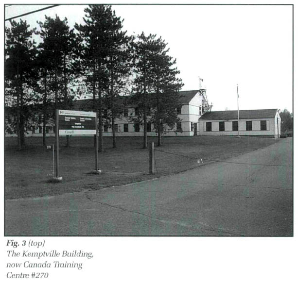
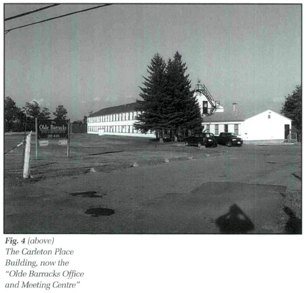
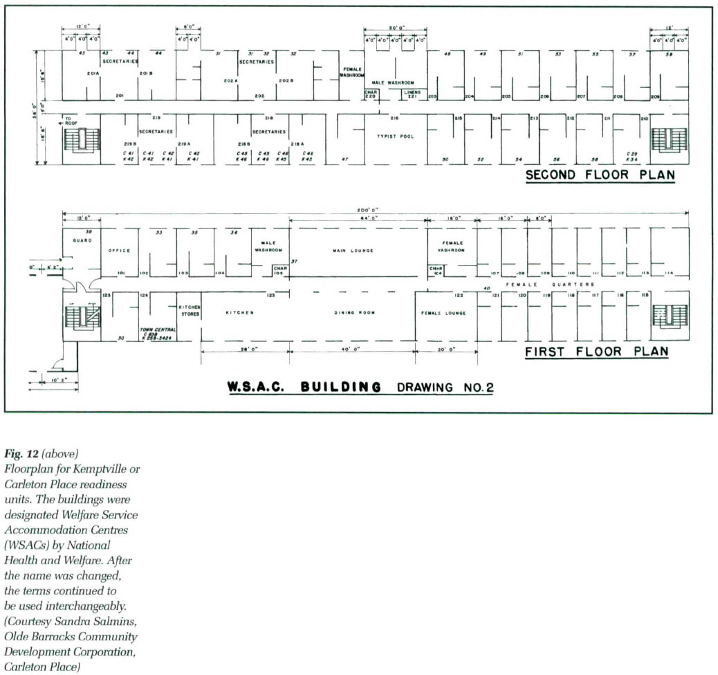
26 The buildings at Kemptville and Carleton Place are the only Canadian Cold War installations in the Ottawa area, apart from the Diefenbunker, to survive to the present time. They are also an interesting case study as they incorporated most of the varied operations associated with both civil and national defence that COG installed to the west of Ottawa, beyond the Diefenbunker. Each is a two-storey frame structure resembling a military barracks, occupying 12 000 square feet above ground and 6 000 below ground. Even today, they are virtually identical in appearance. As to the operations carried out there, both primary and secondary sources tend to use a number of terms interchangeably and obscure their complementary but very distinct roles. The following, it is hoped, will help clear up some of the confusion.
Fig. 3 The Kemptville Building, now Canada Training Centre #270
Thumbnail of Figure 3Display large image of Figure 3
Fig. 4 The Carleton Place Building, now the "Olde Barracks Office and Meeting Centre"
Thumbnail of Figure 4Display large image of Figure 4

Welfare Service Accommodation Centre (WSAC)

27 Ozorak points out that this was the term first used to designate the Kemptville and Carleton Place buildings. It most likely came into use before 1957, when the Department of Health and Welfare was still responsible for civil defence. With the formation of EMO in that year, COG reassigned many of those responsibilities to other federal government departments, and probably introduced the term Federal Readiness Unit to reflect this shared responsibility under EMO co-ordination. Health and Welfare officials, however, continued to refer to both buildings as WSACs throughout the period.
28 The Welfare side of the Department of Health and Welfare retained responsibility for activities consistent with its peacetime mandate. In a national emergency. Welfare was responsible for assisting provincial and municipal governments in feeding, clothing and lodging evacuees, providing emergency aid in cash or in kind, and ensuring the continuity of normal welfare programs, such as the Canada Pension Plan, Family Allowances and Old Age Security. In addition, the Registration and Inquiry Service was mandated to facilitate the reuniting of separated families (e.g., to register and find missing persons), to register evacuees from the disaster area, to register injured persons, and to identify the dead. Welfare planners developed several forms (or rather adapted them from American samples) that included an Unidentified Person Form, a Missing Person Form, a Missing Person Report, a Change of Address Form, and a Safety Notification Card. Each WSAC stockpiled a supply of these forms in the Readiness Unit to be used during the recovery phase to track the changing demographics of the disaster area and to care for those affected.25

Federal Department Relocation Site (FDRS)

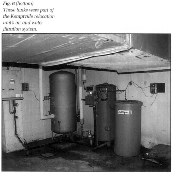
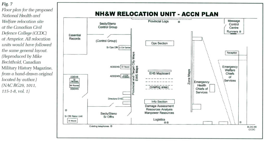
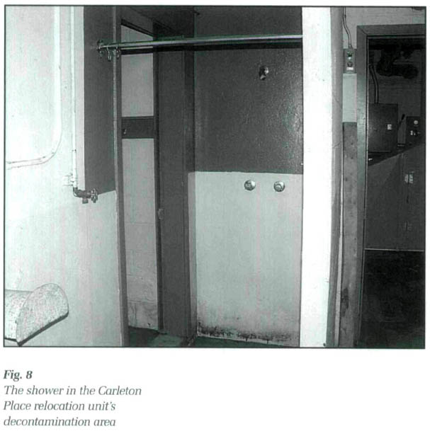
29 Also called Federal Relocation Sites or Central Relegation Units, these protected "fallout shelters" were invariably below ground level. When applied to the Kemptville and Carleton Place buildings, the term properly refers to the basement portion only. Because they were intended to house manning personnel for the duration of the two-week shock phase, they had to be self-contained, reinforced against impact, and radiation proof. Hence, the walls were constructed of thick reinforced concrete. Each shelter had an operations and information display centre, work areas, a kitchen, dining room, dormitories, and a sickbay. Storage rooms contained food, equipment. and supplies to sustain eighty people for fourteen or fifteen days. The message and communications centre and essential records vault were centrally located. Access could be gained only by passing through a decontamination area with a disrobing area, showers, a supply of clean clothing, and a dressing area. It was located at the bottom of the stairway that led down from the front entrance on the ground floor. The facility drew electricity from the local commercial power supply, but standby power was available from an emergency generator. Life support systems included a heating system with fifteen days supply of fuel, air conditioning, and a ventilation system designed to filter outside air for radioactive particles. Relocation sites were constructed on solid bedrock for maximum stability. Occupants drew water from on-site wells.26
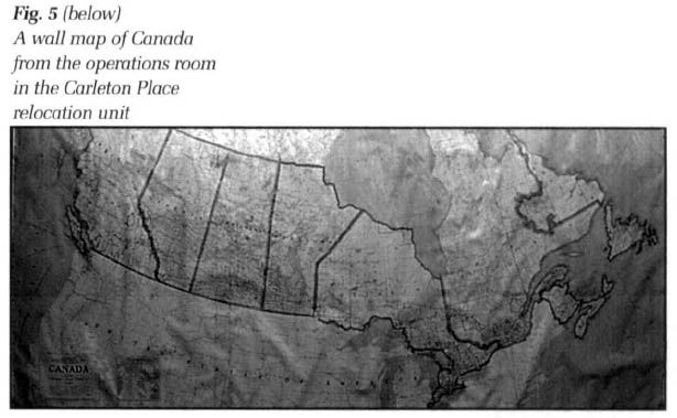
Fig. 5 A wall map of Canada from the operations room in the Carleton Place relocation unit
Thumbnail of Figure 5Display large image of Figure 5
Fig. 6 These tanks were part of the Kemptville relocation unit's air and water filtration system
Thumbnail of Figure 6Display large image of Figure 6
Fig. 7 Floor plan for the proposed National Health and Welfare relocation site at the Canadian Civil Defence College (CCDC) at Arnprior. All relocation units would have followed the same general layout. (Reproduced by Mike Bechthold, Canadian Military History Magazine, from a hand-drawn original located by author. I (NACRG29.1011, 115-1-8. vol. 1)
Thumbnail of Figure 7Display large image of Figure 7
Fig. 8 The shower in the Carleton Place relocation unit's decontamination area
Thumbnail of Figure 8Display large image of Figure 8
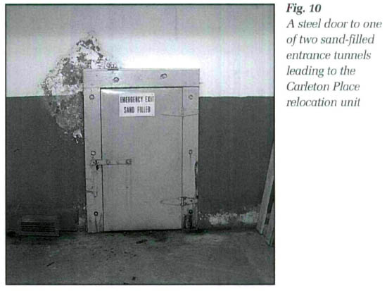
30 Two tunnels led from the exterior to the decontamination area. Personnel could enter or escape the bunker through heavy steel interior doors, while it remained sealed off from the readiness unit. Sand was packed into the tunnels to prevent collapse and provide an airtight seal against radiation, but could be removed to facilitate access or egress, and the tunnels refilled.
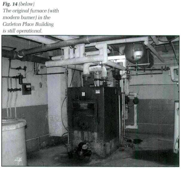
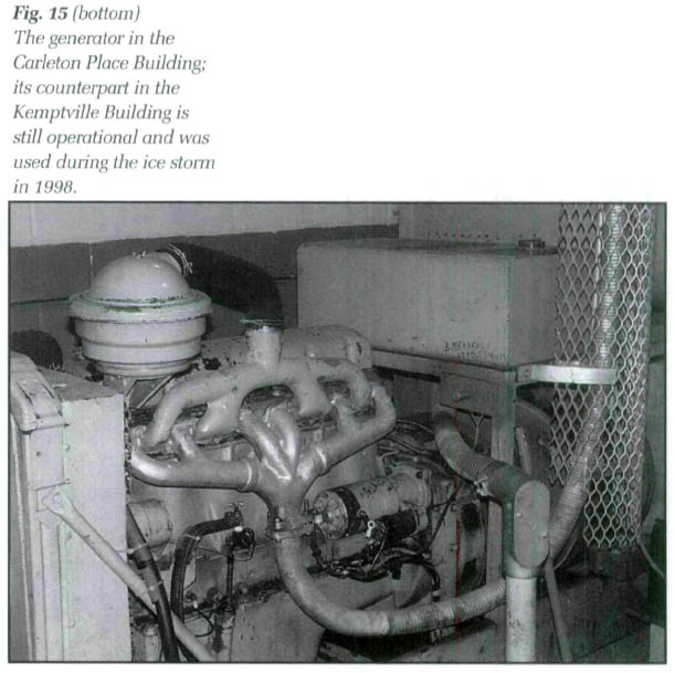
31 Both sites still contain their original diesel generators. The one in Kemptville was still working during the ice storm in 1998. The original furnace is still in use at Carleton Place, although a modern burner has been installed. Much of the old drainage equipment is still operational, but both basements have had periodic problems with water seepage and flooding over the years.27
32 The personnel of a relocation site included an administrative element made up of a site manager, a Department of Public Works engineer, an administrative support person, plus a communications staff of between seven and ten people. In addition, an operational element included a National Health Services home economist, a medical doctor, and an officer from the Royal Canadian Mounted Police (RCMP). The remainder were essential personnel selected from specific government departments (including several ministers and deputy ministers) and given assignments according to the department's manning plan. The total was not to exceed eighty, assuming that only the protected portion of the building was to be occupied.28"
33 Should the officials occupying the Diefenbunker at Carp be unable to carry out their duties for whatever reason, the ministers assigned to the Kemptville relocation site would become the Federal Emergency Government of Canada The larger relocation site at Arnprior, once completed, was intended to assume this "standby" role.29

Federal Readiness Unit

34 A Readiness Unit was distinct from a relocation site in that it was above-ground (in the two two-storey wooden structures at Kemptville and Carleton Place) and was intended to assist the civilian population during the recovery phase. As noted previously, they could be occupied by Relocation site personnel during the shock phase as long as relatively low radiation levels made this feasible.
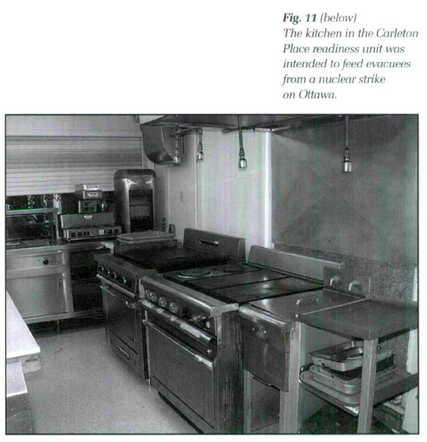
35 Evacuees would need to be fed and sheltered following an attack on Ottawa, and many would have been injured. Space was allocated to store army ration packs, medical kits, sleeping supplies (mattresses, pillows, linens, towels) and clothing. Each building had a hospital unit containing medical equipment, a well-equipped and provisioned kitchen suitable for feeding hundreds of people, and cabinets for reference materials and maps. EMO appointed a site manager (building administrator) to ensure a constant state of readiness. As the number of staff required to coordinate the recovery effort would have increased during an actual emergency, the site manager maintained office space, work areas, meeting rooms, dormitory areas, and storage space for supplies and equipment for their use.30
36 In peacetime, the site manager ensured that the equipment and supplies necessary for recovery would be available on very short notice. Routine duties included acquiring and storing office supplies and furniture and maintaining the equipment (typewriters, duplicating equipment, telephone, teletype, and generator) in good working order. He inspected medical kits every six months and replaced dated or deteriorated components, rotated perishable office supplies and emergency ration packs, ensured that an updated supply of maps and Dominion Bureau of Statistics publications was available, and managed first aid, food handling, sanitary, and radiation reporting procedures. He was also required to "set up and maintain... nuclear reporting post equipment provided by the Army," and to prepare and implement "nuclear reporting procedures." The significance of this will be seen when Nuclear Detonation Reporting Posts (NUDETs) are discussed later on.31

Communications Relay Unit (CRU)

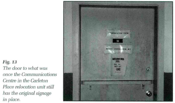
37 A dispersed network of small short-wave radio transmitter/receiver stations called Communications Relay Units (CRUs), also referred to as Communications Centres or Message Centres, was intended for the Ottawa region. These "terminals" had been among DND's earliest priorities, and were to be located, where possible, inside protected facilities. Accordingly, three were installed, one in the each of the protected relocation sites at Kemptville, Carleton Place and Smiths Falls in addition to a number of other locations. The one at Smiths Falls was of particular importance because of its direct link by underground cable to Richardson Detachment. CRUs kept the relocation sites in constant communication with the Diefenbunker, which, in addition to co-ordinating communications at the national and international levels, served as the hub of a local dispersed communications network channeled through Emergency Radio Relay (ERR) System at the Richardson Detachment. While the relocation site was a civilian RUSTIC installation under EMO, the Communications Centre was a military operation that was part of project EASE, its communications specialists being members of 1 Army Signals Squadron. CRUs were equipped with a normal telephone service through the local civil telephone exchange and with special telephone circuits from the Diefenbunker switchboard linked to the local civil telephone exchange. They also had a teletype service through a network of telegraph lines leading to the Diefenbunker. Communications were kept secret through the use of cipher equipment.32
Fig. 9 This motor operated the filtration systems in the Carleton Place relocation unit
Thumbnail of Figure 9Display large image of Figure 9
Fig. 10 A steel door to one of two sand-filled entrance tunnels leading to the Carleton Place relocation unit
Thumbnail of Figure 10Display large image of Figure 10
Fig. 11 The kitchen in the Carleton Place readiness unit was intended to teed evacuees from a nuclear strike on Ottawa
Thumbnail of Figure 11Display large image of Figure 11
Fig. 12 Floorplan for Kemptville or Carleton Place readiness units. The buildings were designated Welfare Service Accommodation Centres (WSACs) by National Health and Welfare. After the name was changed, the terms continued to be used interchangeably. (Courtesy Sandra Salmins, Olde Barracks Community Development Corporation, Carleton Place)
Thumbnail of Figure 12Display large image of Figure 12
Fig. 13 The door to what was once the Communications Centre in the Carleton Place relocation unit still has the original signage in place.
Thumbnail of Figure 13Display large image of Figure 13

Nuclear Detonation Reporting Posts (NUDETs)

38 The Nuclear Detonation and Fallout Reporting System and the National Survival Attack Warning System provided instruments to determine and report the location of ground zero, the height of the burst, the yield of the weapon, the time of detonation and the intensity of the radioactive fallout. Trained specialists would analyze this information to allow for the latest known meteorological data in order to predict and monitor the fallout pattern and issue warnings to the public by means of radio broadcasts or sirens. NUDETs surrounded the sixteen Canadian cities considered potential targets. There were between three and five for each city located in a circular pattern at distances from the target of between 48 and 128 kilometres. For Ottawa, the designated locations for NUDET posts were Arnprior, Carleton Place, and Kemptville.
39 In an emergency, NUDETs were to be monitored twenty-four hours a day, seven days a week. An organization in the immediate vicinity, usually a nearby government agency (federal or provincial), national defence installation, police force or other body acceptable to EMO, had responsibility to maintain the apparatus. At Kemptville and Carleton Place, the Department of National Defence assigned responsibility to EMO. As noted above, this equipment and the operations associated with it were the responsibility of the site manager at both readiness/relocation units. The "manning" agency at Arnprior was to comprise staff of the Canadian Civil Defence College.33

After 1968

40 After the Cuban Missile crisis in 1962, cautious optimism replaced the paranoia of a few years earlier, even as the superpowers were developing more powerful nuclear warheads and more sophisticated delivery systems. The protective measures included in Canada's COG program came to be seen by Canadians as futile, so they turned to the only alternative that made any sense under the circumstances: finding ways to prevent rather than survive international nuclear conflict. Civil Defence in Canada entered a decade of benign neglect. Severe budget cuts beginning in 1968/69 forced EMO to abandon all plans for further development and to maintain those systems and installations already operational.34
41 The Kemptville and Carelton Place facilities were now used primarily as government training centres, providing classroom space to various government departments for training and development programs throughout the 1970s. The RCMP used the Carleton Place PSTC as a training facility from about 1986 to 1990. Following that, the Canadian Security and Intelligence Services (CSIS) occupied it for a number of years. In 1996 it was purchased by the Olde Barracks Community Development Corporation, a non-profit organization whose mandate is to provide community services, which rents out office space and conference facilities.35
42 The RCMP acquired exclusive use of the Kemptville site during the early 1980s and continues to operate it as a training facility.36 In January 1998 the most expensive natural disaster in Canadian history occurred when an ice storm caused massive interruption of electrical power for several weeks, affecting not only southern Ontario, but much of Quebec, the Maritimes and the northeastern United States. The government of Ontario declared a state of emergency and Emergency Preparedness Canada, a successor organization to EMC, whose prime focus is on relief from natural rather than military disasters, deployed army reservists to establish emergency shelters and assist civilian authorities throughout tire affected area. Canadian Forces personnel engaged in relief operations used both the Kemptville and Carleton Place buildings as command centres.
43 The Diefenbunker remained operational until decommissioned by the federal government in 1994. The Municipality of West Carleton purchased the complex and is currently restoring it and operating it as "The Diefenbunker Museum." The Richardson Detachment transmitter site has since been dismantled, but the building was still in place in 1995 when Paul Ozorak took photographs of it to include in his book Bunkers Bunkers Everywhere.37
Fig. 14 The original furnace, (with modern burner) in the Carleton Place Building is still operational.
Thumbnail of Figure 14Display large image of Figure 14
Fig. 15 The generator in the Carleton Place Building: its counterpart in the Kemptville Building is still operational and was used during the ice storm in 1998.
Thumbnail of Figure 15Display large image of Figure 15

Conclusions

44 It is difficult to resist the temptation to compare Canadian Cold War bunkers with their American counterparts which, like Cheyenne Mountain in Colorado, were virtual underground cities. U.S. Secretary of State Henry Kissinger once wrote that "Canadian leaders had a narrow margin for maneuver that they utilized with extraordinary skill."38 The same could be said of Canada's civil defence planners as they attempted to implement a practicable continuity of government program without the vast resources available to the Americans. With restrictions on the size and number of centralized facilities that could be built, they opted for the next best alternative. They dispersed COG operations over a broad area to minimize the possibility of the entire system being put out of action at once, and used existing accommodation whenever possible to minimize the expense.
45 Despite these preparations, Canadian military analysts for the most part continued to believe that the main targets of a Soviet nuclear attack would be in Europe or the United States and that strikes against Canada, if they occurred, would be limited, diversionary, or even accidental.39 Increasingly, they came to the view that if a concentrated attack on the national capital did occur, the destruction would have been massive. One veteran of the program assured the author that it was generally accepted by informed insiders by the mid-1960s that even a "tactical hit" on Ottawa by a Soviet weapon of the magnitude readily available, would have left little of Canada's COG infrastructure intact.40 There is, perhaps, an irony in the timing of Canada's Cold War preparations. The establishment of a functioning COG network and the peak of federal defence spending coincided with the height of international tensions in the Cuban Missile Crisis of 1962. But virtually the moment they became operational the crisis passed, other priorities intervened and they began their decline into obsolescence.
46 The "little bunkers" served their purpose for a brief period of time. But, with the advent of more sophisticated military technologies, the shifting realities of international politics and changing fiscal priorities, they quickly outlived their usefulness. They were successful in one major respect. Given the paramount importance of secrecy for any program of civil defence, they never became well enough known to be forgotten.
ACKNOWLEDGEMENTS
I would like to express my appreciation to the following people for their generous help in preparing this research report: Cold War Historian Paul Ozorak; Brian Dewalt, Curator of Communications Technology at the Canada Science and Technology Museum; Sandra Salmins, Building Manager of the Olde Barracks Conference and Meeting Centre; Doug Hildebrand, Curator of the Canadian Forces Communications and Electronics Museum; Royal Canadian Mounted Police Staff Sergeant Ed MacDonald, and especially Historian Cameron Pulsifer from the Canadian War Museum. The essay is dedicated to the late Bruno Besner, one of the workers who participated in the excavation of the Kemptville "bunker."
NAC — National Archives of Canada
RG 24 — Record Group 24 Department of National Defence (DND)
RG 29 — Record Group 29 Department of National Health and Welfare (NHW)
RG 57 — Record Group 57 Canadian Emergency Measures Organization
NOTES
1 Sean Maloney, ' 'Dr Strangelove Visits Canada: Projects Rustic, Ease, and Bridge, 1958-1963," Canadian Military History 6, no. 1 (Spring 1997): 42-56; Paul Ozorak, Bunkers Bunkers Everywhere (Ottawa: Paul Ozarak, 1998). These should be read in conjunction with David McConnell's excellent organizational history of the Canadian government's preparations for civil defence in the era, The Story of Emergency Preparedness Canada, 1948-1998 (Ottawa, 1998), which can be found on Emergency Preparedness Canada's Web site, www.epc-pcc.gc.ca.
2 Ozorak, Bunkers, Bunkers, chap. 2, p. 5.
3 Ibid., 1-10.
4 R.B. Curry, "The Emergency Measures Organization," Canadian Army Journal 14 (1960): 8-12.
5 David McConnell, "The Diefenbunker: The Central Emergency Government Headquarters at Carp and Continuity of Government," Historic Sites and Monuments Board of Canada Agenda Paper (Ottawa: Parks Canada, 1994), 771.
6 Maloney, "Dr Strangelove," p. 49; McConnell, "Diefenbunker," 771 ; Ozorak, Bunkers, Bunkers, 81-83; the CCDC in Arnprior assumed the role of CEGHQ from Army Camp Petawawa at noon on 27 January 1962, NAC RG 571216-2, vol. 1, R. B. Curry, Director, EMO to Col. H. M. Catiicart, Commander, Camp Petawawa, EMO-1/59 Operation RUSTIC, Parts I and II, 22 January 1962.
7 Maloney, "Dr Strangelove," 49, correctly locates the Richardson detachment in the area between Perth and Smiths Falls, but refers to it incorrectly as Robertson. The Richardson Detachment is not to be confused with the CBC short-wave monitoring station on Richardson Side Road, a few kilometres south of Carp (Ken Gray, "Station Keeps Ear On Static, Not Spies," Ottawa Citizen (13 August 1997), B6). Any connection between the Richardson Side Road facility and the Diefenbunker during the 1950s and 1960s is unlikely since it was standard procedure to locate transmitter parks "... at least 5 miles from both the main building and the remote receiving antenna park." (DND - HQTS 1250-91/B37-1, Project BRIDGE Communications; BRIDGE 1 - British Columbia; 1 June 1960). This document refers to the REGHQ at Nanaimo, but the specifications would have applied to the CEGHQ. The Richardson Side Road installation would have been too close to the Diefenbunker.
8 J. Scanlon, "The Roller Coaster Story of Civil Defence Planning in Canada," Emergency Planning Digest (April-June 1982): 6.
9 "The Rustic Plan is tile basic plan for die warning and movement of Government officials having an emergency assignment at the Central Emergency Government Facilities." NAC RG 57 84-85/658,1216-2, vol. 2, C. R. Patterson, Director General, CEMO, Memorandum for the Minister, 4 August 1966.
10 NAC RG 24 096-103-6,83/84/049, vol. 107 pt. 1, doc. CEP-10/61, Memorandum to the Cabinet Committee on Emergency Plans, Federal Departmental Relocation Sites, Annex. "A," 7 November 1961, pp. 1-3.
11 Maloney, "Dr Strangelove," 47; Ozorak, Bunkers, Bunkers, 86-87.
12 NAC RG 57 84-85/658 1216-2, vol. 1, EMO-l/62, RUSTIC Plan, pp. 7-8.
13 Ibid., 1216-2, vol. 1, R. B, Curry, Director EMO to R. B. Bryce, Clerk of the Privy Council, 2 October 1962.
14 Ibid., 1220-1, vol. 1, Mathewson, Department of External Affairs, to A. R Menzies, Under Secretary of State for External Affairs, 28 March 1962, p. 3.
15 Ibid., 1216-2, vol. 1, EMO-l/62, The RUSTIC Plan says in part; "Departmental parties will assemble at Readiness Units at Kemptville and Carleton Place," the "Revised Plan" dated 5 October 1962 says: "with the exception of EASE, the only fallout protected facilities presently available in me Central Complex are the basements of die Readiness Units at Kemptville and Carleton Place." Ibid., 1225-5, vol. 1, Bergin to Letourneau, Observations (WSAC) Sites Carleton Place and Kemptville, 29 January 1963, alludes to only two functioning relocation sites. Two years later on 5 January 1965, a "note to file" entitled "Federal Department Relocation Units" (ibid., 1216-2, vol. 1) confirms the existence of three, including the one at Smiths Falls. Over a year later on 5 April 1966, the Interim Report on Review of Relocation Plans (ibid., 1216-2, vol. 2) says in part: "we have only 3 relocation units, each capable of housing 80 people in protected accommodation." The Smiths Falls FDRS must therefore have opened between January 1963 and January 1965.
16 McConnell, Emergency Preparedness Canada, chap. 2, 41-13.
17 NAC RG 57 1216-2, vol. 1, Revised Plan, 5 October 1962; Ibid., 1220-1, vol. 1, Col. R. J. Letourneau, CEMO to P. A. Faguy, Director, EMO, Allocation of Space — Arnprior RU, 8 January 1964.
18 Ozorak, Bunkers, Bunkers, 84, lists six "CRUs," including one in Cornwall. Plans for a relocation site in Cornwall had been discussed by EMO, which produced a document entitled "Minimum Requirements for a 250-man Federal Departmental Relocation Unit in the Basement of die Federal Building at Cornwall Ontario" (ibid., 1220-1, vol. 1). Ozorak did not have access to subsequent records indicating that the project was cancelled as early as 1963, e.g., ibid., 1220-1, vol. 2, P. A Faguy, Director, EMO to E. Armstrong, Deputy Minister of National Defence, untitled, 28 April 1963; ibid., 1220-1, vol. 2, P. A. Faguy, Director, EMO to Members of Interdepartmental Advisory Committee on Civil Emergency Planning, IAC-6/64-Departmental Relocation Units at me Central Level, 9 June 1965; also, p. 1, Item 1, R. L Rumerford, Chief, General Planning Division to Director, Planning Branch, Departmental Relocation Units at die Central Level, 9 February 1966.
19 Ibid., 1220-1, vol. 2, R.A. Faguy, Director, EMO to E. B. Armstrong, Deputy Minister of National Defence, untitled, 27 May 1965, ibid., 1220-1, vol. 2, S. N. White, Survival Planning (Technical), CEMO to C. W. Bunting, Director, Continuity of Government Section, EMO, Relocation Unit Accommodation—Kingston, 12 April 1965; ibid., 1220-1, vol. 2, J. F. Wallace, CEMO, to Departmental Committee on Civil Emergency Planning, 31 May 1967.
20 Ibid., 1220-1, vol. 2, Anon., Report of Visit to Relocation Sites at Carleton Place, Kemptville and Smiths Falls, 10 March 1966.
21 The term Public Service Training Centre (PSTC) is first used in 1968 to refer to non-emergency use of die above-ground portions of Kemptville and Carleton Place, but reference is made to "the No. 2 Central Relocation Unit," presumably the basement of one of the above, in 1972; which means that they remained available for that purpose until at least the early 1970s. NAC RG 57 1216-2, vol. 2, J. S. Beeman, Director, Emergency Planning, EMO, to C. W. Bunting, Director, Continuity of Government, EMO, Emergency Planning—Continuity of Government — General — RUSTIC PLAN, 14 February 1972.
22 Ibid., 1220-1, vol. 2, C. R. Patterson, Director General, EMO to Members of the Interdepartmental Committee on Civil Emergency Planning, Central Relocation Units, 17 September 1968, Attach.— Central Relocation Units (Provisional), pp. 3-5. The term Relocation Site was used in different ways. In the late 1950s and very early 1960s, it meant any large building with a basement identified for possible use by manning personnel. When the term appears in official correspondence after about 1962 it generally refers to protected relocation sites. To further confuse matters, EMO continued to identify suitable non-protected buildings for use by groups other than manning personnel, even after the protected basement sites were built. Maloney refers to the Ontario Agricultural College in Kemptville being used as a Relocation Site by "External Affairs." However, close examination of the primary sources shows that the Diplomatic Corps was assigned to the college, while personnel from External Affairs were assigned to the protected basement relocation site beneath the Readiness Unit across town. Maloney also refers to relocation sites in Almonte and Renfrew. If correct, these could only have been unprotected relocation sites. Another possible explanation is that the acronym CRU was sometimes used for central relocation unit as well as communications relay unit. His sources could have been referring to small transmitter/receiver stations in those places. NAC RG 24 096-103-6 83-84/ 049, vol. 107, pt 1, doc. CEP-10/61, Memorandum to Cabinet Committee on Emergency Plans, Federal Departmental Relocation Sites, 7 November 1961, p. 2; RG 57, 84-85/658 1220-1, vol. 1, Mathewson, DEA, 28 March 1962, pp. 2-3; RG 57 1220-1, vol. 1, A. R. Menzies, Under-Secretary of State for External Affairs to "The Director," EMO, 29 March 1962.
23 NAC RG 57, 1220-1, vol. 1, Col. R. J. Letourneau, EMO to P. A Faguy, Director, EMO, Allocation of Space — Arnprior RU, 8 January 1964; ibid., 1220-1, vol. 2, G W. Bunting, Head, Continuity of Government Section, EMO to Chief, General Planning Division, EMO, Relocation Unit — Pembroke Post Office Building, 13 June 1966; ibid., 1220-1, vol. 2, H. S. Bergin, Assistant Head, Emergency Sites Section, EMO, to file, Pembroke Federal Building: Notes and Observations by H. S. Bergin, 16 September 1966.
24 Ibid., 1220-1, vol. 2, Cpl. J. L. P. d'Entrement, Emergency Planning Section to RCMP Civil Security, Survey Report — Emergency Government Relocation Site — Kemptville, Ontario, pp. 2-3,16 May 1968.
25 NAC RG 29 1011115-1-8, vol. 1, Statement on Civil Emergency Planning to the House of Commons Special Committee on Defence, 18 June 1964, pp. 6-7; RG 57 89-90/212 2150-2, G. S. Hatton, Deputy Civil Defence Coordinator, to R. B. Curry, Director, EMO, Post Office role in support of Registration and Inquiry Service of Welfare Program, 24 March 1959 ; R. H. Stehelin, Emergency Welfare Services Division, to Director EMO Registration and Inquiry, 25 September 1959; #WEL-R&I-1, R H Stehelin, The Registration and Inquiry Service, 27 June 1962; RG 24 096-103-6 83-84/049, vol. 107, pt. 2, Emergency Legislation: Other Government Departments, EMOR-WELL11, The Emergency Welfare Regulations Item 2b., 18 December 1962.
26 Ozorak, Bunkers, Bunkers, 88. Some of this information was extracted from "Minimum Requirements for a 250-Man Federal Department Relocation Unit in the Basement of the Federal Building at Cornwall, Ontario." NAC RG 57 84-85/6581220-1, vol. 1, n.d. This material relates to the proposed Cornwall facility, which was never installed, but would have applied to other relocation sites.
27 Ibid., 1220-1, vol. 2, Cpl. J. L. P. d'Entremont, Emergency Planning Section to RCMP Civil Security, re. Survey Report — Emergency Government Relocation Site — Kemptville, Ontario 16 May, 1968, pp. 2-3. During a visit to the former Carleton Place relocation site in December 2000,1 was shown discoloration on the walls, extending three or four feet from the floor, caused by periodic flooding over the years.
28 The number of personnel assigned to a particular site was continually being revised depending on a number of factors, such as the use of "hot bed," the total amount of space available in other designated buildings, the total number of personnel requiring accommodation, and whether unprotected space and/or off-site accommodation was to be used in addition to protected space. Ibid., 1216-2, vol. 2., K. E. Holmes, Operational Readiness Officer, EMO to A. E. Coony, Chief, Operational Services Division, CEMO, EMO Manning Table, 4 April 1966; ibid., 1225-5, vol. 1, H. S. Bergin, Assistant Head, Emergency Sites Section, EMO to Col R. L. Letourneau, Observations (WSAC) Sites Carleton Place and Kemptville, 29 January 1963; ibid., 1220-1, vol. 2, Patterson, op. cit., pp. 1-3; ibid., 1220-1, vol. 2, E. Atkins, Head, Organization and Operations Section, EMO, to file, Establishments — Central Relocation Units, 9 November 1967.
29 Ibid., 1216-2, vol. 2, R A. Faguy, Director EMO, Memorandum for Mr Drury (Deputy Minister of Finance), Designation of Ministers for Emergency Government, 1 September 1964; ibid., 1216-2, vol. 2, Operational Readiness Officer, EMO to A. E. Cooney, Chief, Operational Services Branch, EMO, Rustic Revision (1966), 26 January 1966.
30 Ibid., 1220-1, vol. 1, Col. R J. Letourneau to P. A Faguy, Director, EMO, Emergency Rations, 3 January 1963; ibid., 1220-1, vol. 1, Col. R. J. Letourneau to P. A Faguy, Director, EMO, Equipment and Supplies — Government Emergency Centres, 4 January 1963; ibid., 1220-1, vol. 1, R B. Curry, Director, EMO, to R.B. Bryce, Clerk of the Privy Council, Equipment for Readiness Units — Above Ground Use, 4 January 1964; ibid., 1225-5, vol. 1, R B. Curry, Director, CEMO to B.B. Hart, Rustic Stores, 6 September 1966.
31 Ibid., 1220-1, vol. 1, Col. R. J. Letourneau to P. A. Faguy, Director, EMO, Readiness and Relocation Unit Administration, 14 July 1964, Attach. — Duties of Administrative Officer for Readiness and Relocation Units.
32 Ibid., 1220-1, vol. 2, p. 2, Memo to Members of the Interdepartmental Committee on Civil Emergency Planning, Central Relocation Units, 14 July 1964.
33 Ozorek, Bunkers, Bunkers, 100; Canadian Army Manual of Training: Survival Operations, (Ottawa: 1961), 30-34; "Nuclear Detonation and Fallout Reporting System," A Report Prepared by the Directorate of Survival Operations and Plans, Anny Headquarters, Canadian Army Journal 15, no. 3 (1961): 11-12; EMO National Digest 2, no. 4 (August 1962): 11-12; DSEO V 1150-4110/C42, Annex A, NDFRS/NUDET Posts, DND Working Group on Communications Requirements, p. 2, 31 May 1966; NAC RG 57 84-85/658 1220-1, vol. 1, Col R. J. Letourneau to P. A. Faguy, Director, EMO, Readiness and Relocation Unit Administration, 14 July 1964, Attach. — Duties of Administrative Officer for Readiness and Relocation Units.
34 Ibid., p. 6; McConnell, "Diefenbunker," 777-778.
35 Personal Communication, Sandra Salmins, Property Manager, Olde Barracks Office and Meeting Centre, December 2000.
36 Personal Communication, Staff Sergeant Ed MacDonald, RCMP Training Centre Pstc 270, Kemptville, June 2000.
37 Ozorak, Bunkers, Bunkers, 81-83.
38 Henry Kissinger, The White House Years (New York, 1979), quoted in J. L. Granatstein and Norman Hillmer, For Better or Worse: Canada and the United States to the 1990s, (Toronto, Copp Clark Pitman, 1991), 260.
39 McConnell, "Diefenbunker," 765. See also government documents quoted in the same author's Emergency Preparedness Organization, passim. As it was difficult to determine Soviet plans with any certainty, this view was conjectural, and remains the subject of debate among historians today. To my knowledge, the archival records that could be consulted to clarify the issue remain classified.
40 Personal Communication, Doug Hildebrand, Curator, Canadian Forces Communications and Electronics Museum, Kingston, January 2001.