 The North Warning System is the current ground based radar system, watching Canada's and Alaska's Northern border. Wikipedia has a very complete entry for the NWS, but I have tried to keep the number of sites on the map below limited to those which are active currently and on Canadian soil.
https://en.wikipedia.org/wiki/North_Warning_System
The map (previously posted) of the Mid-Canada Line was in some ways easier to post. There was so little information, there was no duplication. The North Warning System locations, on the other hand, are a little more fuzzy on the map, and the information is hard to validate from multiple competing sources. Some of the current NWS sites were DEW Line stations, and some DEW stations were decommissioned and never reactivated.
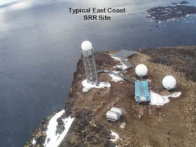
According to Nasittuq, the contractor which takes care of running and resupplying the radar stations, 11 AN/FPS-117 Long Range Radars and 36 AN/FPS-124 Short Range Radars make up the current perimeter.
AN/FPS-117 SEEK IGLOO
 |
| Photo courtesy of Nasittuq (No idea which site this is; Similar to CAM-3 Shepherd Bay) |
Manufacturer: General Electric
T/R Modules: 292 modules
Exact Frequency: 1215 – 1400 MHz
IEEE Band: L Band
NATO Band: D Band
Maximum Range: 200 to 250 nautical miles
MTBF: 1,076 hour specification (original)
Peak Power: 29 kW (with 100 W Peak Power T/R Modules)
Average Power: 5.2 kW (with 100 W Peak Power T/R Modules)
Scan Rate: 5 rpmDuty Cycle: 18%
Pulse Width: 51.2 / 409.6 μS
PRF (PPS): 241
Antenna Gain: 38.6 dBi
Notes: Unmanned 3-D Phased Array Azimuth, Range, and height finding radar that replaced the DEW Line in conjunction with the AN/FPS-124. It can select between 18 randomly selected channels within its frequency band to counter jamming.http://www.alternatewars.com/BBOW/Radar/FPS_Series.htm
AN/FPS-124
 |
| Photo courtesy of Nasittuq (FOX-4 Cape Hooper?) |
NATO Band: D Band (1215 – 1400 MHz)
Minimum Range: 2 miles
Maximum Range: 70 miles
Maximum Altitude: 15,000 ft
Notes: Unmanned doppler radar that replaced the DEW Line in conjunction with the AN/FPS-117.http://www.alternatewars.com/BBOW/Radar/FPS_Series.htm
The map is a work in progress and I will likely update it as better imagery becomes available.
View North Warning System Sites in a larger map
 |
| Extracted from a PDF, converted to PS, then saved as a PNG, this is the best map I could find of the NWS locations. Thank you Nasittuq! |
 |
| Photo courtesy of Nasittuq (Pretty sure that's LAB-2 Saglek) |
Sources:
- The Air Defense Radar Veterans Association
- Wikipedia
- Treasury Board of Canada Secretariat
- Nasittuq (Link)
- http://www.alternatewars.com/BBOW/Radar/FPS_Series.htm
No comments:
Post a Comment