Showing posts with label MCL. Show all posts

June 03, 2015

Mid-Canada Line Locations

"Site Up North"
by Raymond Fortin
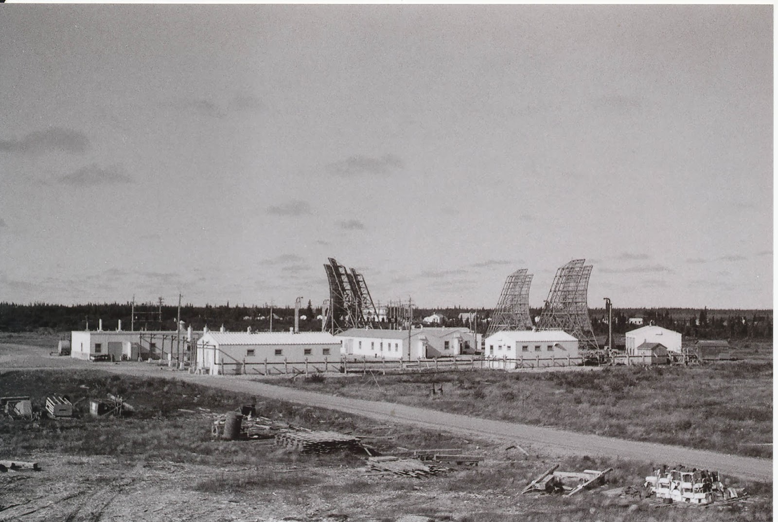
I was very happy to receive in the mail a response to an Access To Information and Privacy request I logged a month ago, and in it was a scan of an old document which clearly documents the coordinates of every single Mid-Canada Line (MCL) site that ever was.  I updated my old 2013 blog post, and here it is!

When satellite imagery wasn't clear, the sites are just placed where they are "supposed" to be.  Assume these are all rounded numbers, and not precise locations.

If you've got pictures of these locations, from the past or present, I'd love to see them!


Special thanks to:
Original Document
  • Archie Gray, Bell Canada I&M Rep, 1957-58
  • Bernard Gervais de L'association des Aviateurs et Pilotes de Brousse du Québec
  • The Department of National Defence Access To Information Act and Privacy team
  • Larry Wilson and his dedication to his web site ( http://www.lswilson.ca/ )
  • Mike Milinkovich, Bell Canada I&M Rep, 1956-59
  • Thomas Page, Gene McManus, and the The Air Defense Radar Veterans Association 
  • (Québec) Ministère du Développement durable, de l'Environnement, de la Faune et des Parcs (The Ministry of Sustainable Development, Environment, Wildlife and Parks)

October 19, 2014

Trip Report: Mid-Canada Line Site 060 and back

Between October 14th and October 18th I was fortunate enough to take a trip into Northern (Northeastern) Ontario to see a few Cold War (and Cold-War Adjacent) sites that were on my bucket list, and was lucky enough to have a travelling companion who was excited to see some of same places as well.  Thank you RH for coming!  We covered over 2,700 km in four days; saw many things, missed some things, took pictures at roadside attractions, didn't die, but the weather didn't really cooperate.  On the other hand, the weather could have been worse, so I shouldn't really complain!


Bo-Mark Motel

(North Bay, Ontario)

On the first night we decided to hit a Motel; it had been raining pretty steadily all day.  Just down the road from the North Bay BOMARC launch facility we found the Bo-Mark Motel... see what they did there?  Naturally, we had to stay there.  From the outside, the Motel looked a little dated, but it was extremely well cared for inside, looks like it has been renovated, and was very clean.  I was impressed.  I would recommend it to any weary travelers.  They were full by 11pm, so be early!  As it turns out, the dog loves sleeping in the truck, and hates sleeping in a motel, so I ended up sleeping in the back of the Suburban with the dog so he didn’t bark all night - it's quite comfortable back there!


Canadian Forces Museum of Aerospace Defence

(North Bay, Ontario)

This radar console was used by the
SAGE system from 1963-1983;
please note the cigarette lighter
and ashtray in the unit
I was very pleased to finally see the Canadian Forces Museum of Aerospace Defence in North Bay.  Their dedicated staff have the support of the Canadian Forces and understand the value of preserving the CF's rich air defence history.  The museum has recently been renovated and has exhibits dating back to WWI; of course, my interest is mainly focused around the Cold War, and I was both thrilled and impressed with the quantity and quality of the materials at the exhibit.  The staff of the museum are extremely knowledgeable and passionate about their work, you will not be disappointed.  If you are passing through North Bay and have an interest in Canadian Air Defence, you should really stop in.  Check their web site for hours www.aerospacedefence.ca

Cockpit selfie in the
CT-133 Silveratar aka "T-Bird"
What about the underground bunker?  Unfortunately there are currently no tours of the former headquarters underground, it is currently being demilitarized and stripped of all military equipment.  Very unfortunate.  Considering how excited I get to see a bare patch of land where a base once stood, I really don’t care that there isn't anything "down in the hole", I don't need a museum down there, I don't even need a formal tour; just open the door!


Here is the official video of the descent into "The Hole":


Jack Garland Airport (YYB)

(North Bay, Ontario)

~10,000ft of runway
capable of supporting any plane in the world.
The administration of the Jack Garland Airport in North Bay astounded me by proving escorted access inside the wire to the Cold-War-era Quick Reaction Alert (QRA) hangers and former munitions storage facility within the grounds of what is now the Jack Garland Airport.  Previously, in case you were not aware, the now-civilian airport was part of CFB North Bay.  The airport's administration are well versed in the history of their airport and appreciate that individuals such as myself are interested in seeing what once would have been inaccessible to the public.  I am very grateful they were so courteous and answered every question possible.  Thanks to them, I was finally able to see the inside of a fairly unmodernised QRA hanger, and see the original three piece hanger doors which are often upgraded to "modern" doors as they break, due to the difficulty of repairing the originals.  They also granted access to the munitions bunker, but I discovered three other people this year has also been knocking; also looking to see those buildings for their own curiosity, hobbies and perhaps business.  If you are them, get in touch!


Former CFB North Bay Quick Reaction Alert (QRA) Hangers

(Jack Garland Airport (YYB))
(North Bay, Ontario)

The inside of the right-most
QRA Hanger
QRA hangers would have been built to keep all-weather interceptors (originally the Avro Canada CF-100 Canuck) fueled for take off, and have pilots stationed right next door in a small barracks building equipped with kitchen and sleeping facilities.  The idea was to have the interceptors fully ready to take flight at a moment's notice.  After initially being used for the CF-100, those same Cold-War-era QRA hangers have continued to be used for every generation of Canadian fighter jet since; even for Canada's latest CF-188 interceptors.

As it was explained to me; the hanger door was originally designed so that the two side doors would swing to the side, the middle door would lift (like a typical garage door), and the two supports would fold up and out of the way to opposite sides.  This design, and having front and back doors open, allows planes to power up and fly right from the hanger, rather than being pulled out before starting up their engines.  The doors are massive, and the counterweights and chains that are part of the mechanism are quite impressive too.  I was told that the leftmost hanger (Northmost in the below picture) burned to the ground, and the pilot's barracks was essentially condemned and demolished years ago.


Former CFB North Bay Munitions Storage Bunkers

(Jack Garland Airport (YYB))
(North Bay, Ontario)

Munitions Storage Bunkers
Reinforced blast shield
As I've mentioned previously; if there's a military airport, there has to be safe storage nearby to store any munitions that might fly in on said aircraft, and that storage needs to meet certain standards that correspond with the munitions that would be stored there.  Property on the location of the former CFB North Bay aerodrome conforms to that theory with earthen-buried bunkers at the end of the runway.  After the airport was split off from CFB North Bay in the 1990s, the bunkers were not demolished, but instead turned into storage for airport-related equipment.  The bunkers are extremely reinforced, engineered to withstand the potential blast from their munitions going off, and buffer any shrapnel or blast from hitting the airport by diverting it upwards (if I understand the design properly).  They show only minor cracks and rust, and are shockingly solid.  All electrical conduits are airtight and to spec for environments where there could be explosives present; I've never seen anything like it!


Near Fraserdale, Ontario


We set up camp near the Fraserdale rail siding near the Abitibi Canyon dam. 
Looking Eastward
near Fraserdale
Considering it was quite late when we set camp, it seemed like the best place we could find in the dark.  Flat, dry-ish after a day of rain, and off the side of an access road by a rail siding.  It was unlikely that anyone would be by, and it seemed safe enough. The next morning one of the locals who lived in Fraserdale stopped by to say Hi, as I'm sure we were a curious site.  I was struck by how friendly everyone was on the trip.  Fraserdale is certainly sparsely populated, but I didn't see any "scary" derelict housing (as I had expected).  I used my camp stove in the morning to make MREs for breakfast, and made coffee before packing up and heading toward Relay, Ontario.


Mid-Canada Line Site 060

(Relay, Ontario)

The MCL site at Relay was already cleaned up, so, except for one pad of concrete and a couple of chopped off telephone polls, there wasn't much... I was struck by how huge the area was that was remediated, and how there's absolutely no hint of the troposcatter antennas, buildings, or anything.
The road to get to the site was ~5km long, and easily walkable within an hour.  What seem to be drainage ditched have been cut into the road, and mesh fastened to the ground presumably to prevent erosion.  These ditches, while inconvenient, were not hard to jump over, and we did not get too wet.  One of the ditches has been dammed by a beaver on the West side, making quite the lake on the West side of the road, and covering the road with water.

View of the former MCL Site 060 from the Northwest end, looking SSE
Jasper, our 8 month old Great Pyrenees posing like a professional model by the train tracks, picture taken looking East
This beautiful Vulpes vulpes, the Northern Red Fox, didn't stick around long when he saw Jasper - but was very curious about us before running off into the tree line.


Travelling from Relay ON to Otter Rapids ON


Prior to taking the trip, using the latest Bing Satellite imagery, I was able to see a path existed on the West side of  the Abitibi, but I couldn’t tell exactly how well maintained that road was.  As it turns out, it's not terrible, but it was a little scary at times.  The road does have mile-markers along the way to give you a hint that you're on the right track, and overall at every road juncture the most travelled road is the "right" road to take when travelling from Relay to Otter Rapids.  I would not recommend this road for any car, it will bottom out and destroy the vehicle.  A 4WD Jeep, truck or large SUV required to make it, IMHO.


Otter Rapids Dam

(Otter Rapids, Ontario)

Overcast skies put a damper on the photography, but the size and power of the water that is flowing through the dam is mind-boggling.  I think this is somewhere more people should make the trip to see.  If I understand correctly, a lot of Toronto's power comes from this generating station.

Unfortunately I did not get any response to my attempts to contact OPG, so I was unable to schedule a tour of the facility.  While Hydro Quebec publicly offers free tours of many of their remote sites, I get the impression OPG doesn't feel any reason to do so.  Thanks a lot, eh.


New Post Falls

(between the Otter Rapids and Abitibi Canyon Dams)

This part of the trip was a failure, partially due to using up all my testosterone and bravery on the segment between Relay and Otter Rapids earlier in the day, partially because we were running out of light, and the weather looked like it was going to suck even more than it had been.  Let me explain.

The plan was to leave the main road (Otter Rapids Road / Green circle), travel along a trail to a spot that has a marked walking trail (Blue circle), and walk to the bottom of where the water from the falls comes out and is more calm; a 15 minute "hike".

Maybe I should have gunned it?
However, along the way we found a large body of water on the trail, and I was concerned that I didn't have sufficient self recovery tools aboard to SS Suburban in case we got stuck or soaked something electrical.  I wasn't sure of the depth or condition of the road under the water, so we decided not to go to New Post Falls that day.  Also influencing the decision was I didn't know exactly how many km we were from the trail head.  Further influencing the decision to turn back was the time of day, less than a half hour from sun down, and it was raining off and on.  The gods were not smiling on us, so we turned back.

Now that I look at the trail on Bing's satellite imagery again, I can see the water hazard on the road just ahead of where we stopped the Suburban.  Also in hindsight, I can see that the waterfall would have been ~6km ahead if we'd walked it from there.  Good to know for next time.

Travelling back to the Abitibi Canyon Dam to cross over in the dark was quite easy on the exceptionally good unpaved road on the East side of the Abitibi River; completely unlike the road on the West side of the river we had taken earlier.


Leave the main road - Green
Planned park and hike - Blue
Significant water on road - Red

Water Hazard as shown on Bing Maps


Country Inn Bar and Grill

(Val Gagne, Ontario)

We made it back as far as Val Gagne that evening and got a room out of the rain.  Jasper was initially very twitchy, as every noise in the Motel made him want to check and see what was what.  Eventually he fell into a deep-enough sleep and let us sleep as well.

While I was apprehensive, since there is an Adult Entertainment establishment next door, the room was actually pretty comfortable, and the bathroom was nice enough (tho dated looking).  Their coffee was absolutely terrible, but their breakfast was delicious - fantastic bacon, sausages and eggs won me over.

Photo Courtesy of RH

Mid-Canada Line Site 070

(Mount Kempis, Ontario)

While there is really nothing left of the Kempis Mountain Troposcatter site
(per my previous blog entries) we did stop to see the view since it seemed appropriate; We'd been to the Air Defence Museum in North Bay, and the next hop in the network at Relay after all!

View of Ramore from Kempis Mountain

In conclusion...


Every time I take a trip like this I learn a little more about how to make the next one better.  As I chew on the experience I expect to make a list of ways I could have improved it... not to take away from the awesome time that I did have, but to say; what could I do better next time?


October 08, 2014

Trip Planning: To Mid-Canada Line Site 060... and back.

New Post Falls
Photo: Andrew McLachlan
Here is the plan for the next trip.

Mid-Canada Line (MCL) sites are rather hard to get to, for me anyway, since the majority were placed along the 55th Parallel.  There are, however, a few sites which stretched South, to bounce the information gathered by the MCL to North Bay.  Those sites were, of course, the troposcatter repeaters stretching South from James Bay.

The Southmost troposcatter repeater is Site 070 (Kempis Mountain, or Mount Kempis) which I've seen before, but hope to see again on my next trip.  It is fully remediated, but provides a fantastic view.

The next hop in the former troposcatter network is 200 km away at Site 060, in Relay, Ontario - a now-non-existent place which once housed diesel generators and radio equipment.  That's where I want to get to. I've never been, and it's pretty much as far North (the 50th Parallel) as you can get in Northeastern Ontario without a canoe.

I will, however, push farther North than that, and aim to get to the Otter Rapids Generating Station, New Post Falls, and see the Abitibi Canyon Dam on the way back.

Two stops in North Bay are planned, and I will document them extensively after they happen.

I had originally been planning to see several of the air strips which were created or upgraded as part of the Pinetree Line project in the early 1950s... however, I discovered there arent many original buildings left at any of the sites... so why bother; sorry to say... My objective was to go somewhere few others have been, and fewer have photographed or documented.  MCL Site 060 at Relay, Ontario fits that bill.


November 30, 2013

Mid-Canada Line Site 410 - Cape Jones

Site 410
From this picture (Credit to Julian Pullara) you can clearly see the landing strip in the background, and the troposcatter antennas in the foreground - along with the buildings which are still standing, and the Diesel storage tanks.

Site Name: Mid-Canada Line Site 410
Location: Cape Jones, Quebec
Built: 1957 
Operational: 1957 - 1965 
Coordinates: 54.63808, -79.74785 
Lot/Concession:
Condition: Abandoned
Current Ownership:Unknown, likely Gov't of Quebec
Distance from paved road: Accessible only by air, perhaps water
Condition of access road: Unpaved


Overview/Background:

A troposcatter repeater station was set up at Cape Jones to transmit across James Bay to Mid-Canada Line Site 415 - Cape Henrietta Maria as well as communicate East to Sector Control Station 400 Great Whale River.


Larry Wilson has pictures on his web site of MCL Site 410
http://www.lswilson.ca/capjones.htm

 
Here is a video about the environmental impact the MCL sites are having on aboriginal communities.


Directions:

There's a gravel airstrip of unknown condition at (54.63960,-79.70678), but I do not know who has landed on it and what condition it is presently in.  Boat access might be easier to arrange.


Trip Report:

I have not yet been to the Mid-Canada Line 410 Cape Jones site, but it is one of the more realistic MCL sites for me to get to.  Unlike MCL Site 415 which is extremely far from road access; Cape Jones isn't too far up the coast from the Cree community of Chisasibi.  Chisasibi is road accessible and at the end of the James Bay Highway.  The general idea being; if I can get that far, what's a little jaunt up the coast in a motor-boat driven freight canoe? (see map below for illustration)


Maps:


Here Maps makes it incredibly difficult, if not impossible, to embed their maps, so here's a link to the best satellite imagery I can find.

http://her.is/L3d7F

Mid-Canada Line Site 410 Cape Jones Troposcatter Site in Red - Landing Strip in Green
atlas.gc.ca


Route from Carp, ON to Chisasibi, QC

View Larger Map

Mid-Canada Line Site 050 - Fort Albany, Ontario


Site Name: Mid-Canada Line Site 050
Location: Fort Albany, Ontario 
Built: 1956
Operational: 1957 - 1965  
Coordinates:
Lot/Concession:
Condition: Remediated
Current Ownership: Unknown
Distance from paved road: Accessible only by air or winter road (January-March)
Condition of access road: Unpaved, walk-able from the airport


Overview/Background:

A troposcatter repeater station was set up at Fort Albany to connect Mid-Canada Line Site 415 Cape Henrietta Maria and Sector Control Station 500 Winisk with Mid-Canada Line Station 060 Relay.

When Fort Albany's Mid-Canada Line troposcatter repeater site was abandoned, the Diesel generators and power distribution equipment continued to be used by the local population, since it was in such close proximity.  In hindsight, if the transformers and electrical equipment which contained PCB contaminated oils, had been taken away at that time, there would likely have been less contamination of the site.  However, the site was left to fester, and contaminate the local environment.  It would seem that the site has now been sufficiently remediated and no further contamination is occurring.

Here is a very detailed report, including maps, pictures and details of the remains of MCL Site 050
http://www.merc.ontera.net/reports/mclrs-01.pdf

Here is a video about the environmental impact the MCL sites are having on aboriginal communities.


Directions:

If you were to fly into Fort Albany, the airport is less than a 2 Km walk from where the site was located (see map below). 


Trip Report:

I have not visited the site, and have no immediate plans to, this is just a palce-holder for the information I've gathered for a potential trip.

The POL site (Diesel Storage) is still standing and fenced off, but east and west of it are bare areas which look to have had buildings.  I am not sure which buildings were at which area, but presume the generators were located to the west where transformers and power lines can still be seen, and barracks to the east where the outline of foundations can be seen.

I believe the picture below (as Mike Milinkovich pointed out) is of Fort Albany, since it has a village in the background.  If so, this picture was likely taken facing Westward, and the power house, housing the diesel generators, is on the left of the picture with a small horizontal Diesel tank peeking around the back of the building from this angle.  This would put this picture as being taken from around where the Diesel tanks are now at the POL site (just left of the green arrow on the map) perhaps from on top of the tank, for the angle, since it looks like it was taken at an elevation.

"Site Up North" - Is this an picture of Fort Albany from the late 1950s?
Photo by Raymond Fortin

Maps:

Mid-Canada Line Site 050 - Fort Albany
atlas.gc.ca

View Larger Map

November 27, 2013

Mid-Canada Line Site 070 - Mount Kempis, Ontario

Site Name: Mid-Canada Line Site 070
Location: Mount Kempis, Ontario
Built: 1956
Operational: 1957 - 1965
Coordinates: 48.3767, -80.2679
Lot/Concession: Cook. Con 1. Lot 12
Condition: Remediated
Current Ownership: Unknown
Distance from paved road: ~1.5Km
Condition of access road: Once off Highway 11 the main access road is North Butler Lake Road, an unpaved but well maintained road.  The side roads to locations of the antennas and where buildings would have been are in good shape, 4-Wheel Drive is not required (but additional clearance for rocks on the road would be beneficial)

Overview/Background:

The Mid-Canada Line was a radar fence set up West-East across all of Canada to supplement the Pinetree Line. The fence proved too remote to be economically feasible, and was shut down only years after it was set up. While it was working, tens of thousands of enlisted personnel and civilian employees constructed and maintained a line of refueling stations and radar outposts across the country. The radar signals gathered were bounced from Fort Albany to Kempis Mountain via Troposcatter Repeaters. Each of the "hops" along the troposcatter repeaters required enormous amounts of power, and because of the remote location of these bases, they were fueled by massive diesel generators. Unfortunately Diesel and lubricants were spilled at many of these locations and left to fester for decades. As a result of the environmental contamination the federal government has started to clean up these locations, dig up the contaminated soil, and the surrounding area, truck off the soil for "disposal", and return the land to as it used to be - more or less. This is unfortunate for me (perhaps the only person in the world who would complain about an environmental cleanup) because the structures, roads, foundations, etc. are being dug up - leaving less for me to see when I go these locations! I'm still visiting these "cleaned up" sites, as the buildings themselves are only one aspect of the location. The view from the tops of the mountains, the journey, the roads, the airstrips, the wildlife, and so forth, make the rest of the adventure for me.

A pair of troposcatter antennas (pointed at the horizon) were on top of Mount Kempis; as well as generators, living quarters, and reportedly even a baseball diamond.  I am not completely certain about all of what was where because it has been so well scrubbed from the site.  A trip to the National Air Photo library is needed, once again, to see aerial imagery from the time.

Directions:

If you are coming from Ottawa, take Highway 11 North from North  Bay until you reach the North Butler Lake Road turn off (48.3728, -80.2567).  North Butler Lake Road is well maintained, but I wouldn't do this trip in the winter.  Once on North Butler Lake Road there will be several turn offs to the right (North).  The first before the hydro line, the 2nd after the hydro line leads to the microwave repeater site, and the 3rd turn to the right leads to the fire tower.

Trip Report:

I have personally visited this site twice.  In late August of 2012, on the way to Northern Ontario, I arrived shortly after dawn and had a look around; after driving there in my 2WD 1999 Dodge Ram.  In 2013 I visited with Mike Milinkovich and stopped in to get a picture of him in front of the plaque commemorating the remediation of the site.  That time I did less driving around on the mountain, but had brought my 1999 (then 2WD) GMC Suburban.  As mentioned above, this is an easily accessible site, there is no 4WD-requirement.

Maps

Mount Kempis
atlas.gc.ca
Google Maps (Pre-Remdiation)

View Larger Map

Bing Maps (Post-Remediation)


Photographs

The images in the below slideshow are the pictures I took in August of 2012.


I'm very thankful to Mike Milinkovich for introducing me to Raymond Fortin who took the following pictures in the late 1950s while he was at Mount Kempis.


Electronic Test Equipment - MCL Site 070 Mount Kempis
Photo by Raymond Fortin


Equipment Room - MCL Site 070 Mount Kempis
Photo by Raymond Fortin


Equipment Room - MCL Site 070 Mount Kempis
Photo by Raymond Fortin


Test Board - MCL Site 070 Mount Kempis
Photo by Raymond Fortin


Entrance to Equipment Room - MCL Site 070 Mount Kempis
Photo by Raymond Fortin


  MCL Site 070 Mount Kempis
Photo by Raymond Fortin


Power House, Diesel Tanks, Living Quarters - MCL Site 070 Mount Kempis
Photo by Raymond Fortin


Troposcatter Antenna @ MCL Site 070 Mount Kempis
Photo by Raymond Fortin
 
Troposcatter Antennas - MCL Site 070 Mount Kempis
Photo by Raymond Fortin
Site Up North
Photo by Raymond Fortin

October 13, 2013

Mid-Canada Line Test Fence - The McGill Fence - Project Spider Web

Picture Curtosey of Dr. James Rennie Whitehead

"One of the double-doppler sites in the Eastern townships.
(Daughter Valerie got into the picture)"
I made a surprising discovery yesterday regarding the locations of the Mid-Canada Line test sites that were built in the Summer of 1953 to test if the radar doppler principle would be able to be used as an effective tripwire-like air defence mechanism.  The chosen technology from these tests would go on to become the Mid-Canada Line.

Frankly, I hadn't paid a lot of attention to the founders of the technology; I was researching the locations where the technology was used - so I was surprised when McGill's Associate Professor Dr. James Rennie Whitehead's name turned up in a Google Search with a significantly enlightening piece of his memoirs.

...It was obvious that flight trials of a test double Doppler system would be essential. We decided to locate a test line along the Ottawa Valley from Ottawa to North Bay. RCA built enough equipments to enable seven or eight stations to be erected and Ross Warren designed a most ingenious antenna which was not going to be too costly.
I should say a word about the double-Doppler principle at this stage. When you receive broadcast TV and an aircraft flies across the line between the TV transmitter and your receiver, the signal fades in and out in a regular way. This is due to the waves reflected from the moving aircraft having a slightly different frequency from those that go directly, because of the Doppler effect. At the receiver the waves reflected from the aircraft interfere with the direct waves to produce the pulsation that you see.
The McGill fence used a refined version of this phenomenon in which the circuits were designed to enhance this effect rather than the transmitted data. Conventional Doppler radars have the transmitter and receiver in the same location. Ours was called “double” because the transmitter and receiver were at opposite ends of each link. With 50’ towers for the antenna, links as long as 30 miles over normal terrain were possible. We planned to have seven in the Ottawa Valley test line.

It was in the summer of 1953 that we set up the test line along the Ottawa Valley from Ottawa to Mattawa, on behalf of the Defence Research Board. There were stations at Ottawa, Arnprior, Haley Station, Meath (near Pembroke), Deep River, Bisset Creek and Mattawa. Each station consisted of a small wooden hut which enclosed a transmitter-receiver unit. A 50-foot scaffolding tower carried a large rectangular antenna, with the reflecting surface made of wire netting. My headquarters for the test line were in a wooden hut on the site of the old prisoner-of-war camp in Deep River. The project carried the code name “Spider Web”...

<snip>

...They agreed to have their K-flight ferry me to an airfield in Killaloe – the nearest suitable airstrip to Deep River – whenever we needed flying. I would be met by station wagon at Killaloe and the aircraft would stooge around until I arrived at the HQ to conduct the tests. Then it would fly back and forth across the line at various heights while we took the observations. ...

Copyright © 1995, J. Rennie Whitehead

This provides several revelations, and poses several problems, for my previous research.

This is one of the few mentions of the Cold War-era airstrip at Killaloe that I've found documented, so I'm pleased to see it mentioned.

Dr. Whitehead confirms that there were 7 radar sites in the test fence.  However; the sites don't all match my previous info.

Dr. Whitehead lists
  1. Ottawa
  2. Arnprior
  3. Haley Station
  4. Meath (near Pembroke)
  5. Deep River
  6. Bisset Creek
  7. Mattawa.

In order, I had listed
  1. South Gloucester (Source: Larry Wilson's MCL web site)
  2. Fitzroy Harbour
    (Source: Larry Wilson's MCL web site)
  3. Haley Station
    (Source: Larry Wilson's MCL web site)
  4. Alice
    (Source: Larry Wilson's MCL web site)
  5. Unknown
  6. Unknown
  7. Mattawa
    (Source: Wikipedia)
Let's review point by point

  1. "Ottawa" could have meant "South Gloucester".  The tower still stands in South Gloucester today, so I do have physical proof that it is the right site, and the radar dishes point NW, toward Arnprior or Fitzroy Harbour.
  2. Arnprior and Fitzroy Harbour are close, relatively, to each other... but they aren't close enough that I'd consider Fitzroy Harbour to be a suburb.  Perhaps Dr Whitehead generalized or figured Arnprior was the closest known landmark?  Doubtful, as he mentioned Bisset Creek and Meath, which are pretty obscure. 
    South Gloucester to Fitzroy Harbour; ~32 Miles
    South Gloucester to Arnprior; ~40 Miles.
  3. Haley Station; at least that lines up. 
    Fitzroy Harbour to Haley Station; 30 Miles
    Arnprior to Haley Station; 22 Miles
  4. Meath is right off HWY17, Alice is 9Km West of the highway.  Alice is 28 Miles from Haley Station, while Meath is 15 Miles from Haley Station.  Optimally the radar sites could be 30 Miles apart; why would one be almost half of that?  This was proof of concept stuff; so maybe varying the distance between the locations was the whole point.
  5. Deep River; as the 5th site I had no idea where this would be, so I can't say that Deep River contradicts my expectation.  Also, Dr Whitehead mentioned he was at the old POW Camp in the middle of Deep River - that's a pretty firm memory and positive location identification.  However; Meath to Deep River is ~35 Miles, past the range of the radar.  Unless Meath wasn't exactly Meath, and it was closer to Deep River along HWY17 - or was at Alice.  Alice to Deep River is ~25 Miles.
  6. Bissett Creek; again, I had no idea where this would be.  There is a large ridge immediately West of Bissett Creek, so I would think the site would be up on the top of that.  To the center of Bissett Creek is 28 Miles from Deep River's POW Camp.  A little West on the ridge?  Maybe ~30 Miles.
  7. Mattawa was the last site in the test fence.  Central Bissett Creek to Central Mattawa is ~32 Miles; if Bissett Creek was really on the ridge, it would be closer to 30 Miles away.
I'd like to ask for clarification, but unfortunately Dr. Whitehead passed away last year after a brief illness at the age of 94.  I hope the national archives have some of the information I'm looking for.

In the meantime, I've integrated those points into my MCL Site Map on Google Maps


View Mid-Canada Line (MCL) Sites in a larger map

September 17, 2013

Falher, Alberta - Mid-Canada Line POL Site

Back in the mid-1950s to mid-1960s the town of Falher, Alberta was used as a supply point for moving Petroleums, Oils and Lubricants (POL) to two stations of the Mid-Canada Line (MCL).  The rail runs through Falher, and rail was the most efficient way to get supplies to the Northernmost reaches of Canada which didn’t have ocean access.

Location of Mid Canada Line Sites near Alberta
Courtesy of Larry Wilson - http://www.lswilson.ca/
MCL Site 830 and MCL Site 833 were part of the MCL radar "fence", and were likely run off Diesel generators.  Supplies such as fuels and lubricants for remote locations of the Mid-Canada Line
had to be flown in by helicopter, but where possible supplies would be trucked.  I have no information to confirm this, but considering roads were in existence around Falher, I have no reason to believe MCL Site 830 and MCL Site 833 were overly difficult to reach by road, so why would expensive helicopter time be used?  MCL Site 830 was southeast of Falher, toward High Prairie, Alberta, and MCL Site 833 was southwest of Falher toward Sexsmith, Alberta.  The exact location where MCL Site 830 or MCL Site 833 were, I'm not entirely sure of.  We can assume the fence would have been placed at relatively high points, and they would have been staggered ~30 miles apart.  Drawing a straight line between Falher and Sexsmith, and Falher and High Prairie we can see the MCL sites would have been south of that arbitrary line.

Credit: The Atlas Of Canada
From the open-source satellite imagery available, the railroad spurs and sidings can be clearly seen.  However, no discernible military or contractor related unloading depot can be identified, by me anyway.  Considering railroad design, unloading would ahve been done on a spur or siding.  Using Google Street View I can see several grain silos, but off hand I do not see any buildings or artefacts that might suggest a previously military use.


I'd like to know where the Falher POL Site was, if it was ever remediated for PCB or other hydrocarbon contamination, and know if there were any buildings built when it was being used as a POL site, or if existing buildings were just repurposed for that time period.

Also, if you know the locations of MCL Site 830 or MCL Site 833, I'd like to know where they were also!

If anything is still at either the location of MCL Site 830 or 833, it's highly unlikely that the building is intact, or the antenna(s).  The antennas, if present, would be lying down, where they were laid to rest when the site was decommissioned around 1964.  However, if anything was there - I'd really like to get a picture of the remains of the facilities and surrounding area.

June 25, 2013

Kempis Mountain - Long Lines / TD-2 Site

Last summer, when I passed through Black River-Matheson I stopped at Kempis Mountain to see the remediated site that was the Mid Canada Line site 070 - the last Tropscatter receiver which fed Doppler radar signals to "The Hole" in North Bay, from Kempis to North Bay by land line.  The signal was skipped off the troposphere from a repeater in Relay, Ontario, repeating the signal from Fort Albany, Ontario.  Anyhow, that was what I was going to look at - and there wasn't much left but a plaque, as the site had been totally "remediated"

Plaque @ MCL Site 070 - Kempis
What I was surprised to find was a rather beefy old steel massive self supporting microwave tower at the peak of the mountain, along with some steel prefab buildings that also looked vintage.

Microwave Tower @ Kempis Mountain
Thanks to the information provided to an expert in the field and in the area (Thank you MM!) I now know this was a 1950s vintage BELL microwave tower, part of the TD-2 / Long Lines system - the first "long haul" coast to coast microwave network which meshed across the USA and Canada proving phone and television signals across the countries.  They really don't make towers like this anymore - there's a lot of steel, not just because the prices were lower, but because the microwave dishes (or Horns) were extremely heavy and the tower needed to be beefy.

Here is a technical journal from 1951 about the TD-2 system
http://www3.alcatel-lucent.com/bstj/vol30-1951/articles/bstj30-4-1041.pdf

...and the later TD-3 system, with diagrams of the buildings
http://www3.alcatel-lucent.com/bstj/vol47-1968/articles/bstj47-7-1511.pdf

1960 Map of AT&T Long Lines Routes
Courtesy of Terry Michaels & Long-Lines.net

If you zoom in on the Ontario section of the map, you'll see Kempis listed, and likely not coincidentally, microwave repeaters follow the Pinetree Line sites along HWY11 pretty well.  Yes, I think I'll be taking pictures of even more old microwave towers in the future. 

Was this one, that I found near Westport, Ontario part of the Bell Long Lines system too?  I'm not sure.  The building was concrete block, not steel.


Decommissioned microwave tower near Westport
I'm always excited to find another element of technology from the Pinetree Line time period, it helps put together the pieces and helps me understand what was, or wasn't, possible at the time.

April 24, 2013

How many posts does it take to make a test-McGill Fence?

Courtesy Canadian Forces
Wikipedia poses an interesting conundrum to my search for where the Mid-Canada Line test fence locations were.  Larry Wilson, who knows his Mid-Canada Line trivia, doesn't mention more than four Ottawa Valley test-fence sites (plus Mont St-Bruno, QC)

From the SE of Ottawa, toward the NW we have the South Glouscester MCL Site 012  which I know is the South-East-most fence "post" because it only has Doppler radar dishes pointing in one direction (Towards Fitzroy Harbour, MCL Site 013)  Fitzroy's tower no longer exists and I haven't found any pictures of it, but as it was a picket fence of sorts, the next stop in the same direction is Haley Station, MCL Site 014.  I don't know the exact location of Haley station, but continuing in that same direction we do get to Alice MCL Site 015, which also no longer exists.  Each of these sites are ~40-50Km apart, and Wikipedia says there were seven sites, ending at Mattawa.  Does that line up with the dots?  Yes it does.  In fact, if there were another three "posts" to the fence at 40-50Km intervals we would end up at Mattawa, and we would have seven Doppler sites in the test fence... as Wikipedia said.

So, I guess I'm not looking for two out of four test sites, I'm looking for five "missing" sites of seven! 

Credit: Bing Maps and Gimp
Indeed, the rough path of where you would expect the next two sites after Alice to be are within the boundaries of Algonquin Park.  So, to clarify, I'm looking for two clearing in the woods, in Algonquin Park that may have exposed or buried cement pads, and potentially an antenna tower, perhaps lying down on the ground, if there at all... right.

Mattawa I've only driven through in the middle of the night, and I don’t know where the test fence site was there either. Clearly more research is needed...