Showing posts with label Mid-Canada Line. Show all posts

June 03, 2015

Mid-Canada Line Locations

"Site Up North"
by Raymond Fortin
I was very happy to receive in the mail a response to an Access To Information and Privacy request I logged a month ago, and in it was a scan of an old document which clearly documents the coordinates of every single Mid-Canada Line (MCL) site that ever was.  I updated my old 2013 blog post, and here it is!

When satellite imagery wasn't clear, the sites are just placed where they are "supposed" to be.  Assume these are all rounded numbers, and not precise locations.

If you've got pictures of these locations, from the past or present, I'd love to see them!


Special thanks to:
Original Document
  • Archie Gray, Bell Canada I&M Rep, 1957-58
  • Bernard Gervais de L'association des Aviateurs et Pilotes de Brousse du Québec
  • The Department of National Defence Access To Information Act and Privacy team
  • Larry Wilson and his dedication to his web site ( http://www.lswilson.ca/ )
  • Mike Milinkovich, Bell Canada I&M Rep, 1956-59
  • Thomas Page, Gene McManus, and the The Air Defense Radar Veterans Association 
  • (Québec) Ministère du Développement durable, de l'Environnement, de la Faune et des Parcs (The Ministry of Sustainable Development, Environment, Wildlife and Parks)

October 08, 2014

Trip Planning: To Mid-Canada Line Site 060... and back.

New Post Falls
Photo: Andrew McLachlan
Here is the plan for the next trip.

Mid-Canada Line (MCL) sites are rather hard to get to, for me anyway, since the majority were placed along the 55th Parallel.  There are, however, a few sites which stretched South, to bounce the information gathered by the MCL to North Bay.  Those sites were, of course, the troposcatter repeaters stretching South from James Bay.

The Southmost troposcatter repeater is Site 070 (Kempis Mountain, or Mount Kempis) which I've seen before, but hope to see again on my next trip.  It is fully remediated, but provides a fantastic view.

The next hop in the former troposcatter network is 200 km away at Site 060, in Relay, Ontario - a now-non-existent place which once housed diesel generators and radio equipment.  That's where I want to get to. I've never been, and it's pretty much as far North (the 50th Parallel) as you can get in Northeastern Ontario without a canoe.

I will, however, push farther North than that, and aim to get to the Otter Rapids Generating Station, New Post Falls, and see the Abitibi Canyon Dam on the way back.

Two stops in North Bay are planned, and I will document them extensively after they happen.

I had originally been planning to see several of the air strips which were created or upgraded as part of the Pinetree Line project in the early 1950s... however, I discovered there arent many original buildings left at any of the sites... so why bother; sorry to say... My objective was to go somewhere few others have been, and fewer have photographed or documented.  MCL Site 060 at Relay, Ontario fits that bill.


January 05, 2014

Mid-Canada Line Sector Control Station 500 - Winisk


Site Name: Mid-Canada Line Sector Control Station 500
Location: Winisk, Ontario
Built: 1956
Operational: 1957 - 1965 
Coordinates: 55.24440, -85.10944 
Lot/Concession:
Condition: Remediated (2011-2013) 
Current Ownership:Province of Ontario
Distance from paved road: Accessible by air, ice-road, water
Condition of access road: NA


Overview/Background:

Sector Control Stations along the Mid-Canada Line were the manned backbone of the radar system.  They were technical, organizational and transport hubs.  Sector Control Station 500 "Winisk" was located near the community of Winisk, that was wiped out by a flood in 1986 and relocated.  The site of SCS 500 was remediated between 2011 and 2013, some satellite photos even show the vehicles parked at the airstrip that were used for the remediation.

Southwest of the station is the airstrip, I believe Northeast of the station was a dredged channel allowing barges of fuel and supplies to be dropped off.

Directions:

There's not much hope of getting to Winisk in the summer without a plane, but there has previously been an ice road access.

Trip Report:

This is just a place-holder in case I ever do get to Winisk


Pictures:

Some of the last photos of Winisk before everything was torn down.
Photos courtesy of Julian Pullara, and were taken in the fall of 2012.

Winisk air strip


Winisk Fire Hall


Road from the air strip to the station


The Winisk air strip control tower


Larry Wilson has vintage pictures on his web site of SCS 500
http://www.lswilson.ca/scs500.htm


Maps:


View Larger Map

November 30, 2013

Mid-Canada Line Site 410 - Cape Jones

Site 410
From this picture (Credit to Julian Pullara) you can clearly see the landing strip in the background, and the troposcatter antennas in the foreground - along with the buildings which are still standing, and the Diesel storage tanks.

Site Name: Mid-Canada Line Site 410
Location: Cape Jones, Quebec
Built: 1957 
Operational: 1957 - 1965 
Coordinates: 54.63808, -79.74785 
Lot/Concession:
Condition: Abandoned
Current Ownership:Unknown, likely Gov't of Quebec
Distance from paved road: Accessible only by air, perhaps water
Condition of access road: Unpaved


Overview/Background:

A troposcatter repeater station was set up at Cape Jones to transmit across James Bay to Mid-Canada Line Site 415 - Cape Henrietta Maria as well as communicate East to Sector Control Station 400 Great Whale River.


Larry Wilson has pictures on his web site of MCL Site 410
http://www.lswilson.ca/capjones.htm

 
Here is a video about the environmental impact the MCL sites are having on aboriginal communities.


Directions:

There's a gravel airstrip of unknown condition at (54.63960,-79.70678), but I do not know who has landed on it and what condition it is presently in.  Boat access might be easier to arrange.


Trip Report:

I have not yet been to the Mid-Canada Line 410 Cape Jones site, but it is one of the more realistic MCL sites for me to get to.  Unlike MCL Site 415 which is extremely far from road access; Cape Jones isn't too far up the coast from the Cree community of Chisasibi.  Chisasibi is road accessible and at the end of the James Bay Highway.  The general idea being; if I can get that far, what's a little jaunt up the coast in a motor-boat driven freight canoe? (see map below for illustration)


Maps:


Here Maps makes it incredibly difficult, if not impossible, to embed their maps, so here's a link to the best satellite imagery I can find.

http://her.is/L3d7F

Mid-Canada Line Site 410 Cape Jones Troposcatter Site in Red - Landing Strip in Green
atlas.gc.ca


Route from Carp, ON to Chisasibi, QC

View Larger Map

Mid-Canada Line Site 415 - Cape Henrietta Maria

Mid Canada Line Radar Site 415
Photo: Julian Pullara
Site Name: Mid-Canada Line Site 415
Location: Cape Henrietta Maria, Ontario
Built: 1957 
Operational: 1957 - 1965  
Coordinates: 54.732, -82.408 
Lot/Concession:
Condition: Remediated?
Current Ownership: Unknown
Distance from paved road: Accessible only by air, perhaps water
Condition of access road: Unpaved


Overview/Background:

A troposcatter repeater station was set up at Cape Henrietta Maria to transmit across James Bay to Mid-Canada Line Site 410 - Cape Jones as well as communicate with Sector Control Station 500 Winisk.  I'm unclear how the DDS sites between Cape Jones and Cape Henrietta Maria communicated with each other, as I believe there were two on the Bear Islands.  Also, I'm unclear how Cape Henrietta Maria communicated with Winisk.


Larry Wilson has pictures on his web site of MCL Site 415
http://www.lswilson.ca/scs400.htm
Here is a very detailed report, including maps, pictures and details of the remains of MCL Site 415
http://www.merc.ontera.net/reports/mclrs-01.pdf

Here is a video about the environmental impact the MCL sites are having on aboriginal communities.


Directions:

There's a gravel airstrip of unknown condition at (54.756213, -82.398964) that is just north-east of where the Cape Henrietta Maria site was.  Good luck!

Here is a video from someone who flew in, in spring of 2012.

Trip Report:

I have not visited the site, would love to, but realistically I don't see it happening without major financial backing.  This is just a palce-holder for the information I've gathered for a potential trip.

Maps:


Mid-Canada Line Site 050 - Fort Albany, Ontario


Site Name: Mid-Canada Line Site 050
Location: Fort Albany, Ontario 
Built: 1956
Operational: 1957 - 1965  
Coordinates:
Lot/Concession:
Condition: Remediated
Current Ownership: Unknown
Distance from paved road: Accessible only by air or winter road (January-March)
Condition of access road: Unpaved, walk-able from the airport


Overview/Background:

A troposcatter repeater station was set up at Fort Albany to connect Mid-Canada Line Site 415 Cape Henrietta Maria and Sector Control Station 500 Winisk with Mid-Canada Line Station 060 Relay.

When Fort Albany's Mid-Canada Line troposcatter repeater site was abandoned, the Diesel generators and power distribution equipment continued to be used by the local population, since it was in such close proximity.  In hindsight, if the transformers and electrical equipment which contained PCB contaminated oils, had been taken away at that time, there would likely have been less contamination of the site.  However, the site was left to fester, and contaminate the local environment.  It would seem that the site has now been sufficiently remediated and no further contamination is occurring.

Here is a very detailed report, including maps, pictures and details of the remains of MCL Site 050
http://www.merc.ontera.net/reports/mclrs-01.pdf

Here is a video about the environmental impact the MCL sites are having on aboriginal communities.


Directions:

If you were to fly into Fort Albany, the airport is less than a 2 Km walk from where the site was located (see map below). 


Trip Report:

I have not visited the site, and have no immediate plans to, this is just a palce-holder for the information I've gathered for a potential trip.

The POL site (Diesel Storage) is still standing and fenced off, but east and west of it are bare areas which look to have had buildings.  I am not sure which buildings were at which area, but presume the generators were located to the west where transformers and power lines can still be seen, and barracks to the east where the outline of foundations can be seen.

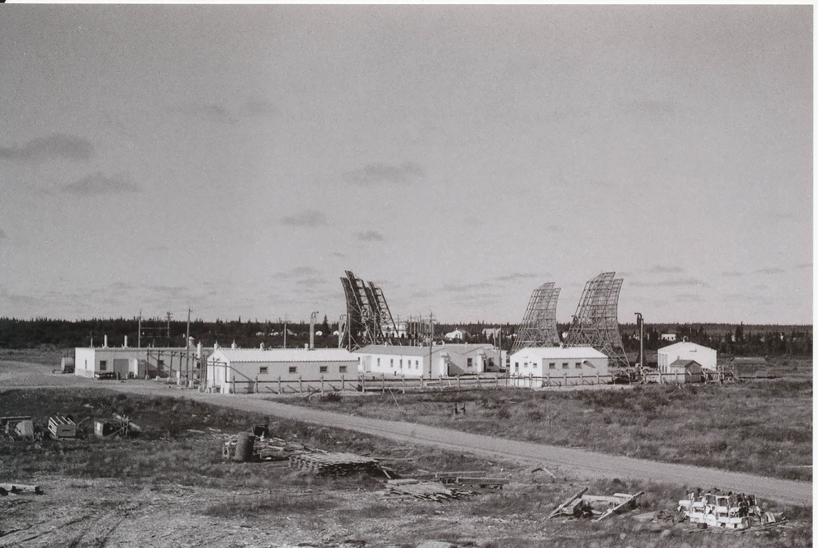
I believe the picture below (as Mike Milinkovich pointed out) is of Fort Albany, since it has a village in the background.  If so, this picture was likely taken facing Westward, and the power house, housing the diesel generators, is on the left of the picture with a small horizontal Diesel tank peeking around the back of the building from this angle.  This would put this picture as being taken from around where the Diesel tanks are now at the POL site (just left of the green arrow on the map) perhaps from on top of the tank, for the angle, since it looks like it was taken at an elevation.

"Site Up North" - Is this an picture of Fort Albany from the late 1950s?
Photo by Raymond Fortin

Maps:

Mid-Canada Line Site 050 - Fort Albany
atlas.gc.ca

View Larger Map

October 13, 2013

Mid-Canada Line Test Fence - The McGill Fence - Project Spider Web

Picture Curtosey of Dr. James Rennie Whitehead

"One of the double-doppler sites in the Eastern townships.
(Daughter Valerie got into the picture)"
I made a surprising discovery yesterday regarding the locations of the Mid-Canada Line test sites that were built in the Summer of 1953 to test if the radar doppler principle would be able to be used as an effective tripwire-like air defence mechanism.  The chosen technology from these tests would go on to become the Mid-Canada Line.

Frankly, I hadn't paid a lot of attention to the founders of the technology; I was researching the locations where the technology was used - so I was surprised when McGill's Associate Professor Dr. James Rennie Whitehead's name turned up in a Google Search with a significantly enlightening piece of his memoirs.

...It was obvious that flight trials of a test double Doppler system would be essential. We decided to locate a test line along the Ottawa Valley from Ottawa to North Bay. RCA built enough equipments to enable seven or eight stations to be erected and Ross Warren designed a most ingenious antenna which was not going to be too costly.
I should say a word about the double-Doppler principle at this stage. When you receive broadcast TV and an aircraft flies across the line between the TV transmitter and your receiver, the signal fades in and out in a regular way. This is due to the waves reflected from the moving aircraft having a slightly different frequency from those that go directly, because of the Doppler effect. At the receiver the waves reflected from the aircraft interfere with the direct waves to produce the pulsation that you see.
The McGill fence used a refined version of this phenomenon in which the circuits were designed to enhance this effect rather than the transmitted data. Conventional Doppler radars have the transmitter and receiver in the same location. Ours was called “double” because the transmitter and receiver were at opposite ends of each link. With 50’ towers for the antenna, links as long as 30 miles over normal terrain were possible. We planned to have seven in the Ottawa Valley test line.

It was in the summer of 1953 that we set up the test line along the Ottawa Valley from Ottawa to Mattawa, on behalf of the Defence Research Board. There were stations at Ottawa, Arnprior, Haley Station, Meath (near Pembroke), Deep River, Bisset Creek and Mattawa. Each station consisted of a small wooden hut which enclosed a transmitter-receiver unit. A 50-foot scaffolding tower carried a large rectangular antenna, with the reflecting surface made of wire netting. My headquarters for the test line were in a wooden hut on the site of the old prisoner-of-war camp in Deep River. The project carried the code name “Spider Web”...

<snip>

...They agreed to have their K-flight ferry me to an airfield in Killaloe – the nearest suitable airstrip to Deep River – whenever we needed flying. I would be met by station wagon at Killaloe and the aircraft would stooge around until I arrived at the HQ to conduct the tests. Then it would fly back and forth across the line at various heights while we took the observations. ...

Copyright © 1995, J. Rennie Whitehead

This provides several revelations, and poses several problems, for my previous research.

This is one of the few mentions of the Cold War-era airstrip at Killaloe that I've found documented, so I'm pleased to see it mentioned.

Dr. Whitehead confirms that there were 7 radar sites in the test fence.  However; the sites don't all match my previous info.

Dr. Whitehead lists
  1. Ottawa
  2. Arnprior
  3. Haley Station
  4. Meath (near Pembroke)
  5. Deep River
  6. Bisset Creek
  7. Mattawa.

In order, I had listed
  1. South Gloucester (Source: Larry Wilson's MCL web site)
  2. Fitzroy Harbour
    (Source: Larry Wilson's MCL web site)
  3. Haley Station
    (Source: Larry Wilson's MCL web site)
  4. Alice
    (Source: Larry Wilson's MCL web site)
  5. Unknown
  6. Unknown
  7. Mattawa
    (Source: Wikipedia)
Let's review point by point

  1. "Ottawa" could have meant "South Gloucester".  The tower still stands in South Gloucester today, so I do have physical proof that it is the right site, and the radar dishes point NW, toward Arnprior or Fitzroy Harbour.
  2. Arnprior and Fitzroy Harbour are close, relatively, to each other... but they aren't close enough that I'd consider Fitzroy Harbour to be a suburb.  Perhaps Dr Whitehead generalized or figured Arnprior was the closest known landmark?  Doubtful, as he mentioned Bisset Creek and Meath, which are pretty obscure. 
    South Gloucester to Fitzroy Harbour; ~32 Miles
    South Gloucester to Arnprior; ~40 Miles.
  3. Haley Station; at least that lines up. 
    Fitzroy Harbour to Haley Station; 30 Miles
    Arnprior to Haley Station; 22 Miles
  4. Meath is right off HWY17, Alice is 9Km West of the highway.  Alice is 28 Miles from Haley Station, while Meath is 15 Miles from Haley Station.  Optimally the radar sites could be 30 Miles apart; why would one be almost half of that?  This was proof of concept stuff; so maybe varying the distance between the locations was the whole point.
  5. Deep River; as the 5th site I had no idea where this would be, so I can't say that Deep River contradicts my expectation.  Also, Dr Whitehead mentioned he was at the old POW Camp in the middle of Deep River - that's a pretty firm memory and positive location identification.  However; Meath to Deep River is ~35 Miles, past the range of the radar.  Unless Meath wasn't exactly Meath, and it was closer to Deep River along HWY17 - or was at Alice.  Alice to Deep River is ~25 Miles.
  6. Bissett Creek; again, I had no idea where this would be.  There is a large ridge immediately West of Bissett Creek, so I would think the site would be up on the top of that.  To the center of Bissett Creek is 28 Miles from Deep River's POW Camp.  A little West on the ridge?  Maybe ~30 Miles.
  7. Mattawa was the last site in the test fence.  Central Bissett Creek to Central Mattawa is ~32 Miles; if Bissett Creek was really on the ridge, it would be closer to 30 Miles away.
I'd like to ask for clarification, but unfortunately Dr. Whitehead passed away last year after a brief illness at the age of 94.  I hope the national archives have some of the information I'm looking for.

In the meantime, I've integrated those points into my MCL Site Map on Google Maps


View Mid-Canada Line (MCL) Sites in a larger map

September 18, 2013

Sexsmith, Alberta and High Prarie, Alberta - Mid-Canada Line POL Sites

Location of Mid Canada Line Sites near Alberta
Courtesy of Larry Wilson - http://www.lswilson.ca/
On the heels of my post about Falher, Alberta; I got to thinking...  There are only so many times a month that barrels of Diesel would need to be shipped from the rail yard to the MCL Site.  The location of Falher, as it served only two MCL DDS sites, wouldn’t have been a bustling military town in any way.  In fact, the trucks used might not have been military at all.  Since only two DDS sites were being ferried fuel, and a truck can carry more barrels than a helicopter, it probably wasn't much of an operation in Falher.  Any warehouse would do, so it begs the question, was there a purpose-built building, or did they just lease some space from someone by the rail?  Is that building still there?

Then I looked East and West at the next POL points; Sexsmith and High Prarie are, in regard to the MCL, in a similar position to Falher.  Both are on the rail.  Both near two MCL DDS sites.  High Prarie and Sexsmith today both have many concession roads that lead off into rural Alberta, and I suspect it was the same in the late 1950s when the MCL was built.  While in Quebec and Ontario it was standard procedure to ferry fuel to the stations by heavy/medium lift helicopter, maybe out West there was no need.  In Ontario and Quebec the sites were considerably more remote, and there were very few roads of any kind anywhere near the sites.  I still have no firm indication which MCL Sites were road vs helicopter accessible.

I think this complicates finding anything in Sexsmith, Falher or High Prarie.  At the Pinetree Line sites, or MCL SCS Sites, there were a lot of buildings and a lot of infrastructure, they were hard to miss.  These POL sites may have just been a non-descript warehouses, and not very different than any other building in town.


High Prarie, Alberta
atlas.gc.ca


Sexsmith, Alberta
altas.gc.ca


September 17, 2013

Falher, Alberta - Mid-Canada Line POL Site

Back in the mid-1950s to mid-1960s the town of Falher, Alberta was used as a supply point for moving Petroleums, Oils and Lubricants (POL) to two stations of the Mid-Canada Line (MCL).  The rail runs through Falher, and rail was the most efficient way to get supplies to the Northernmost reaches of Canada which didn’t have ocean access.

Location of Mid Canada Line Sites near Alberta
Courtesy of Larry Wilson - http://www.lswilson.ca/
MCL Site 830 and MCL Site 833 were part of the MCL radar "fence", and were likely run off Diesel generators.  Supplies such as fuels and lubricants for remote locations of the Mid-Canada Line
had to be flown in by helicopter, but where possible supplies would be trucked.  I have no information to confirm this, but considering roads were in existence around Falher, I have no reason to believe MCL Site 830 and MCL Site 833 were overly difficult to reach by road, so why would expensive helicopter time be used?  MCL Site 830 was southeast of Falher, toward High Prairie, Alberta, and MCL Site 833 was southwest of Falher toward Sexsmith, Alberta.  The exact location where MCL Site 830 or MCL Site 833 were, I'm not entirely sure of.  We can assume the fence would have been placed at relatively high points, and they would have been staggered ~30 miles apart.  Drawing a straight line between Falher and Sexsmith, and Falher and High Prairie we can see the MCL sites would have been south of that arbitrary line.

Credit: The Atlas Of Canada
From the open-source satellite imagery available, the railroad spurs and sidings can be clearly seen.  However, no discernible military or contractor related unloading depot can be identified, by me anyway.  Considering railroad design, unloading would ahve been done on a spur or siding.  Using Google Street View I can see several grain silos, but off hand I do not see any buildings or artefacts that might suggest a previously military use.


I'd like to know where the Falher POL Site was, if it was ever remediated for PCB or other hydrocarbon contamination, and know if there were any buildings built when it was being used as a POL site, or if existing buildings were just repurposed for that time period.

Also, if you know the locations of MCL Site 830 or MCL Site 833, I'd like to know where they were also!

If anything is still at either the location of MCL Site 830 or 833, it's highly unlikely that the building is intact, or the antenna(s).  The antennas, if present, would be lying down, where they were laid to rest when the site was decommissioned around 1964.  However, if anything was there - I'd really like to get a picture of the remains of the facilities and surrounding area.

August 29, 2013

Mike Milinkovich's stories of the Mid-Canada Line


Last year I visited the former Troposcatter receiver site at Kempis Mountain for the first time, where the signal from Relay was received from the Mid-Canada Line farther north, and shunted to North Bay via land-line.  Realistically, I don't know how many other Mid-Canada Line related sites I'll be able to reach.  Hopfully Relay Ontario (MCL Site 060) next year, we'll see.
However, I've made contact with someone who worked on the Mid-Canada Line, is local to Ramore, and who's been able to pinpoint for me where the Ramore GATR Site was.  Mike has lots of stories about his time on the Mid-Canada Line.  The more stories I hear of the Mid-Canada Line and Pinetree Line, the more I realize there are vast volumes of untold Canadian stories that are waiting to become books, biographies, and screenplays.
Originally published on Larry Wilson's Mid-Canada Line "War Stories" page on his web site here and here I've reposted Mike Milinkovich's stories below, with Mike's permission.
I opened the MCL “War Stories” to read and was struck by how many people wrote of their experiences at 309 DDS! I’m not superstitious, but I really wonder if there were “spirits” other than those found in a bottle that made 309 DDS their home?
I was the first 309 DDS “tech” or the “Installation & Maintenance Representative” as Ma Bell called us. After graduating from the third wave from the MCL School in Montreal as a bright-eyed and bushy-tailed 20-year old I arrived on site in the early fall of 1956.
I lived in a tent for the first 3-4 months while the living quarters and equipment/power rooms were being built. After 53 years I would like to relate some of my experiences, events and occurrences that some may find interesting.
  • The first time I ever flew in a single engine fixed wing aircraft was the flight from Knob Lake to 309 DDS lake head. The pilot seemed crazy to me. I got in the plane, sat right beside the pilot and we took off. In a few minutes he reached into his jacket pocket and took out a pocket book that he propped up somehow between his knees and the joy stick and we bounced along on what I thought was a rough flight until we floated down to land on the lake. He never said a word to me the whole time up in the air but just read his damn book, landed, came to a stop at the dock then told me to get my bags and get out of his plane!
  • We had no water on site; water was brought in by two pails hanging down from a yoke carried by one of our Portuguese labourers from a lake about one mile downhill and one mile back up. I bet he developed the strongest legs in Canada as he did this for many hours every day!
  • That lake was also full of speckled trout. I had a few artificial lures that never worked well so I got the idea of tying a small hook to a wooden match stick that I had shaved back to create “curls”. The first cast, a trout took it within seconds. I used those wooden match sticks as “trout flies” from then on!
  • Washing clothes was a problem until we decided to use our cement mixer. It worked fine but it sure beat the heck out of our clothes!
  • We had a burly looking cook who spent about 4 months at 309 DDS; he was a nice enough guy, especially as he was always mildly drunk and in good humour with the home brew he made from tomato juice. One day a helicopter dropped in with two Mounties on board. They took our cook away. He was wanted for multiple murders in Montreal!
  • We had a “cookie” that was mildly mentally handicapped but a very good worker. Three “Newfy” steel riggers came and spent a little over a month erecting towers. From almost the first day that they arrived they teased the cookie mercilessly. The final morning when the Newfies were leaving and waiting for the helicopter, one of them apologized to the cookie and said they were sorry for teasing him and hoped he would forgive them. The cookie accepted their apology, said he forgave them, and also said from then on he would stop pissing in their coffee pot!
  • The bush pilots flying supplies into our site were unbelievable. That first winter we had very heavy winds blowing day after day for weeks. This caused snow drifts at least 3 to 4 feet high that looked like waves on the lake where the planes normally landed. We were running really short of food and fuel so one of the pilots said he would try to land. He did, miraculously, without crashing and with a full load.
  • 309 DDS was located in an area that was surrounded by a number of lakes, some fairly large. All of them had fantastic fishing. One spot I always wanted to try and fish was the Caniapiscau River. Although you could see the river from our site it was too far away to walk through the rough bush and up and down some fairly steep hills. At a guess, I think the river was about 8 to 10 miles from our site.
  • One of the best fishing spots I used to go to quite often was to a large lake about 4 – 5 miles South West of our DDS site. My favourite spot was also the favourite spot of black bears. A narrow but deep creek ran into the lake at the location I usually fished. On both sides of the creek, foot paths were worn quite deep into the soil over the years by bears fishing in the spring for spawning suckers. When the ice started to melt off the lake and there was about 50 – 75 feet of open water you could catch beautiful lake trout each weighing anywhere from 10 to 25 pounds with almost every cast. Most of these I just let go and only brought back one or two because the 4 – 5 mile walk back to camp was uphill all the way!
  • I had heard a story that one of the Installation & Maintenance reps that came after me, who was Australian, was killed by a black bear at 309 DDS. I often wondered if he was killed at “my” fishing spot. There certainly were a lot of bears around there but I never actually saw one; just their tracks, paths and claw marks where they marked their territory on trees.
  • One of the very few times that I flew into Knob Lake I bought a shotgun. There were a lot of ptarmigans around the site that I wanted to hunt so I bought a Winchester pump action .410 shotgun. I had never seen a .410 pump action before. It was a beautiful little shotgun. Soon after I bought it I went hunting. It was really cold, at a guess about -30 with a pretty stiff breeze that probably created a wind chill of around -40. I quickly came upon a covey of ptarmigan, about 4 or 5. I released the safety, drew a bead and pulled the trigger. Nothing happened! I thought the shell must be bad so I tried to pump in another. The pump action was jammed! I couldn’t do a darn thing. The birds all flew away. Ptarmigan are not afraid of humans and you can usually get close to them but eventually they do move away. I was so disgusted with my pretty little shotgun that I traded it for a short wave radio a week or so later to one of the construction crew. That was a dumb thing to do but I was young and could be considered “unworldly” if not downright stupid. The problem with the shotgun was that I had used ordinary gun grease. I should have used graphite gun grease! The grease I did use simply froze in the extremely low temperature and completely jammed the shotgun. I have never seen a .410 pump action Winchester shotgun since that time way back in 1956. It was an unusual shotgun that I wished I had today as I now live in the country with a lot of good partridge hunting close by.

These are just some of the stories from a time in my life when every day was a wonderful challenge and every experienced was relished. I felt so lucky that I was able to travel to the far north and see a part of Canada that few Canadians ever have a chance to see. After the Mid Canada line, I worked on the DEW line on Baffin Island and Winisk and finally on the Pine tree line where I visited each military radar site in Canada from Holberg on the tip of Vancouver Island to Newfoundland. I was on loan to the DND Inspection Services on the Pine tree line. It was during one of my Mid Canada assignments South of Matheson Ontario at site 070, Kempis Mountain, that I met and married the most beautiful and wonderful girl in the world and we are still together. Below is a picture of her at 68 years old as the “BRM Belles” Red Hat Queen at the Matheson Fall Fair.


Mike also happens to be the Mayor of the township surrounding Ramore; The Township of Black River-Matheson.  Since Mike worked along the Mid-Canada Line and at Kempis Mountain, it seemed appropriate that in 2009 when the site was shut down, he was involved, and wrote this.


The Final Chapter for Mid Canada Line Site 070
By: Mike Milinkovich
Mike Milinkovich August 28th 2013 @ Kempis Mountain

November 12, 2009 is the day that the final chapter was written about the “Cold War” that began just after WW II between the Soviet Union and the Western allies. I began work at Kempis Mountain in the late 1950’s and participated in the ceremony on November 12th that signalled the final chapter in the history of “Mid-Canada Line site 070” in the Township of Black River-Matheson.

The establishment of the North American Air Defence Command (NORAD) coincided with the flight of Russia’s Sputnik I (the first man-made object shot into space orbit) and the successful launch of the first Soviet Intercontinental Ballistic Missile (ICBM). The Canadian and American government’s agreement to create NORAD to counter a Soviet nuclear-armed bomber threat was reached in August 1957 and formally signed in May 1958.

Subsequently the three early warning radar detection systems built in the late 1950’s, the U.S.-built Distant Early Warning (DEW) Line, the Canadian built and manned Mid-Canada Line (MCL), and the jointly erected Pinetree Line became critical NORAD components.

In 1955-56, Kempis Mountain, also known as Mid-Canada Line site 070 was built. Site 070 was the last link of a chain of Mid-Canada Line communications sites that stretched north to Hudson Bay. Site 070 was not a radar site but a communication site linked to similar sites at site 060 (also called Relay and located 80 miles North of Cochrane), site 050 at Ft. Albany and finally to site 415 located at Cape Henrietta Maria on the western shore of James Bay.

Data that was collected by the Mid-Canada Line Doppler Detection Sites (Radar sites) was transmitted south from site 070 by land line to the “Hole” in North Bay. The “Hole”, as it was called, was the co-located headquarters for the northern region of NORAD. The other NORAD headquarters site was located in the Cheyenne Mountains in Colorado. Together, these two sites controlled North American defences against potential threats from the air by analyzing data and information from the northern radar lines to determine if jets had to be scrambled to meet potential threats from attacking forces.

During the construction of site 070 and during the years it was manned, people from the Township of Black River-Matheson played a big part. The road up Kempis Mountain and the levelling of the site for construction was done primarily by the late Vic Hembruff’s company now called R. J. Lougheed Trucking Ltd. and currently owned by Bob Lindsay. Much of the concrete work and construction was completed by a company called H & D Construction and owned at the time by the late Ernie Dambrowitz and Floyd Hembruff. Sadly this company no longer exists. Many people from the towns of Holtyre, Matheson, Ramore, Shillington and Val Gagne also worked for years at various occupations at the site.

Unfortunately one of the dangerous legacies left behind at all the sites across Canada including site 070 is an organic chemical compound called “Polychlorinated biphenyl” or as commonly known, PCBs. This chemical was commonly used for many years in various types of electronic equipment installed at all the sites. In addition, tests were conducted to identify Hydrocarbons and metals and when found were removed.

You may ask, “So what’s the big deal?” The big deal is that PCBs are classified as “persistent organic pollutants” meaning PCBs never degrade or disappear but persist in the environment and accumulate in human and animal tissue. The only way to get rid of it from the environment is to remove it and destroy it by various methods at specially designed facilities. PCBs can cause serious health problems in humans and other mammals such as lowering of the immune system, birth defects, health problems such as cancer and diabetes or a failure by males to reproduce.

The team that successfully completed the cleanup operation over a relatively short timeframe began work on site August 26, 2009 and completed the project in November 2009. The team included representatives from the Matachewan First Nation (MFN), SNC-Lavalin Inc. (SLI), Golder Associates Innovative Application (GAIA), an affiliate of GAIA’s called Golder Associates Limited (GAL), AirZOne One (OZO), and the Ministry of Natural Resources (MNR).

By the end of the project the team had removed over 17,000 tons of material from Kempis Mountain. This material was trucked to sites in Quebec and other locations in Ontario for proper disposal. In total 2342 samples of soil, leachate, hydrocarbons, concrete, bedrock, PCB wipe tests for non-porous materials and water were tested for contaminates.

As Mayor, I was honoured to be asked to participate in the closing ceremonies to represent the Township of Black River-Matheson and also from a personal perspective as one of the “survivors” whose site 070 story began over 50 years ago. From 1956 to 1961 it was my privilege to have worked on all three Radar lines; MCL, DEW and Pinetree. I worked in every Province in Canada from the tip of Vancouver Island at Holdberg to Newfoundland and Labrador, in the Northwest Territories and further north above the Arctic Circle on Baffin Island. This experience profoundly cemented my deep love and appreciation of this wonderful country of ours at an early age.

We should all be thankful that the Federal and Provincial governments have agreed to work together to fund the cleanup of this cold war era mess so future generations of Canadians will be protected. In particular the Ontario government’s Ministry of Natural Resources (MNR) and Minister Donna Cansfield should be congratulated for becoming the lead agency in coordinating the cleanup efforts.

I wish them luck and God speed in cleaning up all the other sites in Northern Ontario.

Mike Milinkovich, Mayor
Township of Black River-Matheson


April 24, 2013

How many posts does it take to make a test-McGill Fence?

Courtesy Canadian Forces
Wikipedia poses an interesting conundrum to my search for where the Mid-Canada Line test fence locations were.  Larry Wilson, who knows his Mid-Canada Line trivia, doesn't mention more than four Ottawa Valley test-fence sites (plus Mont St-Bruno, QC)

From the SE of Ottawa, toward the NW we have the South Glouscester MCL Site 012  which I know is the South-East-most fence "post" because it only has Doppler radar dishes pointing in one direction (Towards Fitzroy Harbour, MCL Site 013)  Fitzroy's tower no longer exists and I haven't found any pictures of it, but as it was a picket fence of sorts, the next stop in the same direction is Haley Station, MCL Site 014.  I don't know the exact location of Haley station, but continuing in that same direction we do get to Alice MCL Site 015, which also no longer exists.  Each of these sites are ~40-50Km apart, and Wikipedia says there were seven sites, ending at Mattawa.  Does that line up with the dots?  Yes it does.  In fact, if there were another three "posts" to the fence at 40-50Km intervals we would end up at Mattawa, and we would have seven Doppler sites in the test fence... as Wikipedia said.

So, I guess I'm not looking for two out of four test sites, I'm looking for five "missing" sites of seven! 

Credit: Bing Maps and Gimp
Indeed, the rough path of where you would expect the next two sites after Alice to be are within the boundaries of Algonquin Park.  So, to clarify, I'm looking for two clearing in the woods, in Algonquin Park that may have exposed or buried cement pads, and potentially an antenna tower, perhaps lying down on the ground, if there at all... right.

Mattawa I've only driven through in the middle of the night, and I don’t know where the test fence site was there either. Clearly more research is needed...

April 23, 2013

Looking for the Mid-Canada Line Test Fence


Around 1953 the Canadian government erected a series of proof of concept test sites to demonstrate the possibility of using the Doppler effect to detect airplanes in an early warning system that would come to be deployed along the 55th parallel, the Mid-Canada Line (MCL for short).

There were four tests sites around Ottawa that worked together to create a "fence"

Alice, Ontario (MCL Site 015)
Haley Station, Ontario (MCL Site 014)
Fitzroy Harbour, Ontario (MCL Site 013)
South Glouscester, Ontario (MCL Site 012)

The exact locations of two of these sites are believed to be known (Alice and South Glouscester) but the other two are not known by anyone I know of.  So, I'm currently looking for historical evicence from primary sources that can corroborate those that are known, and discover those that are not known.

The best primary source that I can think of is physical evidence at the site, and South Glouscester has that - somehow the antenna with all of it's gear at the top is still standing (since the 1950s! See pics here)

From the satellite pictures, Alice doesn't look to have any physical evidence at the site, but the driveway is still there...

I've started speaking to locals in Fitzroy Harbour to see where the antenna might have been.  I know of at least two DND properties in the area which had many antennas on them, but none with a single tower with gear at the top, as it should look.  From discussions yesterday with one of the long time residents of Fitzroy Harbour, the antenna might have been where there is a new tower today, here:


View Larger Map

I also discovered there's a local historical society, so contacting them is next on my list!